GeoShot Technologies Completed Large City Modeling Project Using LiDAR Data
 GeoShot Technologies has successfully completed large city modeling using LiDAR data. “We are very excited to complete the first large scale city modeling project at GeoShot Technologies at a time when 3D city modeling demand is accelerating.” said Manoj Pal, LiDAR Manager.
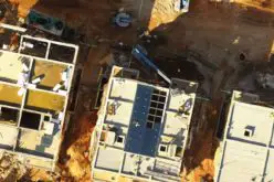
Geoshot processed raw LIDAR point cloud to get the advanced classified data. Then GeoShot generated topographic map and Digital Elevation Model using ortho photo and point cloud. Using classified building points, 3D buildings, transmission lines and tree positions have been generated. The data exported to 3DS Max for further detailing and texturing of the city model. The final data delivered to client in 3DS Max file format. “Our 3DS Max department is excited to complete the first large scale city modeling project at GeoShot Technologies where we did the texturing and detailing from LiDAR data. This process saved a lot of time by introducing LiDAR technology.” said Prabasi Maharana, Architectural 3D Manager.
Proper town planning system is essential need for urbanization of any town or city. There are various techniques which are currently used for town planning by companies but the most accurate, versatile and fast measurement technique is LiDAR.LiDAR play important role in obtaining 3D city models. The 3D city models in urban territories are vital for some applications, for example, disaster management, military operations, mapping of buildings and their heights, simulation of new structures, change detection and virtual reality, updating and keeping cadastral data.
Airborne laser scanning is a comparatively new technology for capturing data of the topography of the earth. It became more feasible through the availability of lasers with special attributes and the Global Positioning System (GPS). LiDAR has revolutionized the acquisition of digital elevation data for large scale mapping applications.
About GeoShot Technologies:
LiDAR Data Services (LDS) is a leading LiDAR data service provider to worldwide clients and is a division of GeoShot Technologies. Our team have been involved in all types of LiDAR technologies and advanced LiDAR processes. LiDAR Data Services provide high resolution data deliverables at cost effective prices to its clients across the globe.
LDS has been involved in diverse range of LiDAR projects. From delivering large scale projects to executing small scale LiDAR mapping projects worldwide, we are skilled at adapting cost-effective approaches. Our client base includes renowned LiDAR survey companies in Europe, North America and Australia.