Optech Presenting the Latest Mapping Solutions for Geosciences at EGU 2015

ILRIS and the geo-XR6 UAV combine their strengths
for rapid, lightweight surveys in difficult terrain
April 8, 2015 — Optech is pleased to announce that it will attend the 2015 European Geosciences Union (EGU) General Assembly in Vienna, Austria on April 12-17 to discuss the use of lidar and remote imaging for geoscience, particularly the combination of small unmanned aerial vehicles (UAVs) and terrestrial lidar scanners (TLS).
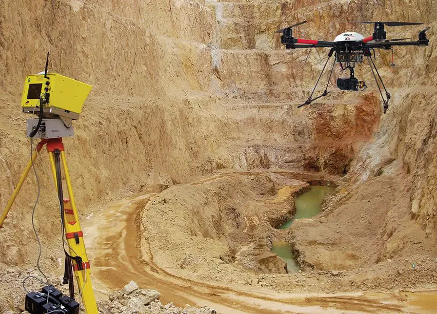
Worldwide Channel Partner Manager for Terrestrial Laser Scanner Products Dario Conforti will present “Combining terrestrial laser scanning and UAV photogrammetry for fast and lightweight surveying” at 3:50 pm on Thursday, April 16 at PICO Spot 3. This short presentation describes how terrestrial lidar and camera-equipped UAVs can combine their strengths to deliver accurate colorized lidar data and georeferenced imagery of outdoor targets such as open-pit mines, rock hazards and geologic formations. The presentation will be followed at 4:00 pm by an hour of interactive discussion at PICO Screen 3.5, where attendees can go into greater detail with Dario about the solution and its features, such as how the horizontal perspective of the TLS complements the vertical view of the UAV to ensure that the entire target is captured.
Optech staff will be ready to answer questions during the exhibition about the latest remote-sensing solutions for the geosciences. This includes Optech’s own TLS/UAV solution, which combines the rugged Optech ILRIS TLS and the new Optech XR6 photogrammetry UAV in an integrated software workflow. Staff will also have information about other tools for geology and mining, ranging from the Optech CMS Cavity Monitoring System for safe long distance surveying to Optech’s array of airborne lidar and camera solutions for multi-sensor wide-area mapping. This includes the world’s first commercial multispectral lidar, which opens amazing new possibilities in feature identification and spectral classification day or night. Visitors can find Optech in Booth G17 alongside our partner geo-konzept GmbH in the Green Level (first floor) of the Exhibition Gallery.
About Optech:
Optech is the world leader in high-accuracy lidar 3D survey systems, integrated cameras, and productivity-enhancing workflows. With operations and staff worldwide, Optech offers both standalone and fully integrated lidar and camera solutions for airborne mapping, airborne lidar bathymetry, mobile mapping, terrestrial laser scanning, mine cavity monitoring, and industrial process control, as well as space-proven sensors. Optech systems are also fully warrantied, with extended warranty packages offered by Optech Technical Solutions. Accuracy and productivity matter!
For further information, please contact your Regional Sales Manager or:
Wayne Szameitat
International Sales Manager
Optech
300 Interchange Way Vaughan,
Ontario, Canada L4K 5Z8
+1 905 660 0808
inquiries@optech.com