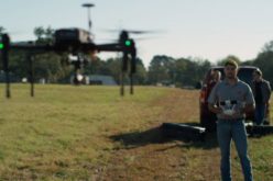
PrecisionHawk and Skyward Partner to Provide Full-Service Drone Platform to Commercial Customers
PrecisionHawk’s leading UAVs, data mapping and analysis software and LATAS safety platform will be connected to Skyward’s operations management platform to provide a holistic drone workflow for the commercial market
Raleigh, North Carolina and Portland, Oregon – PrecisionHawk and Skyward, global leaders in the UAV industry, have come together to assemble a complete package of technology tools to increase efficiency across the commercial market. The partnership provides a one-stop shop for customers to plan, map, manage and analyze their assets using a drone platform.
The partnership includes three components:
- The integration of Skyward’s flight operations system with the Lancaster drone, the DJI-PH Smarter Farming package and PrecisionHawk’s DataMapper.
- Skyward’s airspace intelligence tools will be integrated into PrecisionHawk’s LATAS safety platform.
- When used together, customers will gain access to a seamless end-to-end commercial platform, from planning to aerial data collection to analysis.
“As we continue to grow our offerings on a global scale, PrecisionHawk is always looking for ways to better serve its customers by adding tools that are easy, automated and efficient,” said Christopher Dean, PrecisionHawk Co-Founder and President. “This partnership with Skyward allows us to provide a complete commercial drone offering to the market. We are excited to partner with Skyward and bring this holistic offering to our customer base.”
Through this partnership, customers of PrecisionHawk and Skyward will have access to an end-to-end commercial drone operations management platform.
“PrecisionHawk provides best-in-class hardware and software for the agriculture, aggregates, insurance, and energy industries, and we’re proud to join forces to give these companies more tools to access the sky safely and grow their businesses,” said Jonathan Evans, Skyward CEO. “Drone operators need resources to efficiently manage fleets and get accurate airspace intelligence. This partnership builds on the robustness of the existing PrecisionHawk platform.”
For package more information visit PrecisionHawk (www.precisionhawk.com) or Skyward (www.skyward.io/precisionhawk).
About Skyward
About Skyward Skyward (www.skyward.io) is the first operations management platform for commercial drone operations. The cloud-based software integrates an interactive drone airspace map with flight planning tools and a digital system of record. Skyward was founded by career pilots and computer science experts with a mission to ensure that the standards of safety and professionalism are carried into this new era of aviation. For the latest Skyward news, follow us on Twitter @SkywardIO or read our blog (www.skyward.io/blog).
About PrecisionHawk Inc.
PrecisionHawk is a terrestrial data acquisition and analysis company founded in 2010. The company provides an end-to-end solution using Unmanned Aerial Vehicles (UAVs) for data collection and analysis software tools to deliver better business intelligence to clients across a wide range of civilian industries. PrecisionHawk also owns terrestrial data software, DataMapper, satellite imagery imagery provider, Terraserver, and the Low Altitude Tracking and Avoidance System for drones, LATAS. A privately held company based in Raleigh, NC and Toronto, Canada, PrecisionHawk’s investors include Intel Capital, Dupont Ventures, Verizon Ventures, Millennium Technology Value Partners, Yamaha Motor Ventures, NTT Docomo Ventures, USAA Ventures and the Innovate Indiana Fund. More information about PrecisionHawk can be found at www.precisionhawk.com or on Twitter @PrecisionHawk.