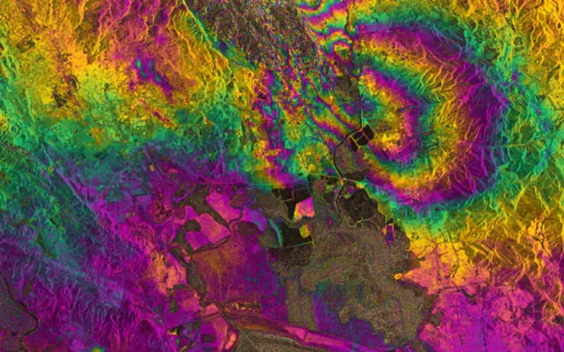
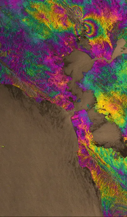
Sentinel-1 maps earthquake; Photo: ESA
Sentinel-1A has added yet another string to its bow. Radar images from this fledgling satellite have been used to map the rupture caused by the biggest earthquake that has shaken northern California in 25 years.
Scientists collaborating through the UK Natural Environment Research Council’s Centre for the Observation and Modelling of Earthquakes, Volcanoes and Tectonics (COMET), used Sentinel-1A’s special capabilities to analyse the quake.
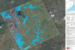
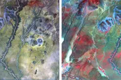
‘Synthetic aperture radar interferometry’ is a technique where two or more satellite radar images of the same area are combined to detect large-scale surface changes. Small changes on the ground modify the reflected radar signal and lead to rainbow-coloured fringes in the ‘interferogram’.
Yngvar Larsen from Norway’s Northern Research Institute and Petar Marinkovic from PPO.labs in the Netherlands processed this new interferogram from two images: one that Sentinel-1A acquired on 7 August, the day the satellite reached its operational orbit, and another captured on 31 August.
It clearly confirms that part of the West Napa Fault system was responsible for the 6.0 earthquake that rocked California’s wine-producing region. However, the fault had not been identified as being particularly hazardous prior to the quake that hit on 24 August.
It clearly confirms that part of the West Napa Fault system was responsible for the 6.0 earthquake that rocked California’s wine-producing region. However, the fault had not been identified as being particularly hazardous prior to the quake that hit on 24 August.
Importantly, the extent of the ground deformation in the interferogram shows that the fault slip continues further north than the extent of the rupture mapped at the surface.
Sharp lines in the interferogram show minor movements on other faults, such as the part of the West Napa Fault system that crosses Napa airport.
COMET Director, Tim Wright, from University of Leeds said, “This successful demonstration of Sentinel-1A marks the beginning of a new era for our ability to map earthquakes from space.
“COMET scientists are building a system that will provide these results routinely for all continental earthquakes, as well as mapping the slow warping of the ground surface that leads to earthquakes.”
Austin Elliott, a PhD student at the University of California Davis, one of the team mapping the earthquake rupture on the ground, said, “The data from satellites are invaluable for completely identifying the surface break of the earthquake – deformation maps from satellite imagery guide us to places where rupture has not yet been mapped.”
Although Sentinel-1A is still being commissioned, ESA was able to respond specifically to the incident and provide data rapidly to the science team.
Sentinel-1 radar vision; Photo: ESA
Betlem Rosich-Tell, ESA’s Project Manager for the Copernicus Sentinel-1 Payload Data Ground Segment, noted, “I’m very pleased to see that the dedication from the various Sentinel-1 ground segment teams, both at ESA and at industry, meant that we could react to an emergency at this early stage in the mission and provide an ‘out-of-the-box utilisation’ of Sentinel-1A data.
Prof. Andy Hooper, also at the University of Leeds, added, “This satellite represents a sea change in the way we will be able to monitor catastrophic events such as earthquakes and volcanic eruptions in the future, due to its systematic observation strategy.”
“The Sentinel-1 ground segment is designed to fully exploit the potential of the mission by acquiring, processing and delivering a huge amount of high-quality data products in a timely manner for both operational and scientific applications.”
Sentinel-1A passes over the same spot on the ground every 12 days. However, once its identical twin, Sentinel-1B, is launched in 2016, this will be cut to just six days, so that changes can be mapped even faster.
Source: ESA