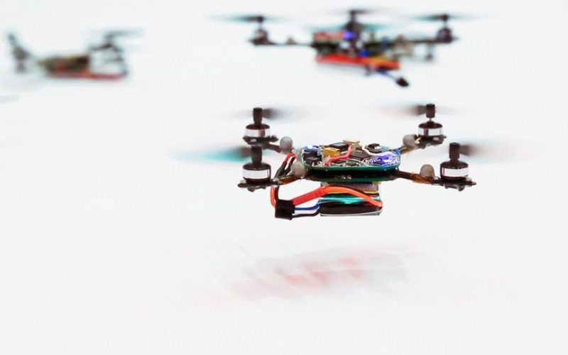
In a recent news released by the University of Buffalo, inspired by birds and insect behavior soon swarms of flying drones will be mapping oil spills.
Souma Chowdhury, Assistant Professor, Department of Mechanical and Aerospace Engineering is pioneering a way to program a team of drones to quickly map an oil spill.
His computational efforts, in a paper which he co-authored with UB students Zachary Ball and Philip Odonkor, were presented in January at the American Institute of Aeronautics and Astronautics’ Science and Technology Forum. The study, called “A Swarm-Intelligence Approach to Oil Spill Mapping using Unmanned Aerial Vehicles,” optimized and simulated a five-drone swarm that can map a nearly one-kilometer wide spill in nine minutes.
To make that work, Chowdhury had to overcome the lack of communication bandwidth typical of a flying ad hoc network and the short battery life of off-the-shelf drones.
Following the principles partly inspired by the dynamics of a flock of birds, Chowdhury devised a method for the drones to quickly record whether they are over water, oil or the edge of the spill. In addition, the drones assume that the space around the oil they have spotted is also oil, although that is recorded as less than certain. This simple information is shared with the other drones in the swarm, as opposed to sharing actual images or video, which would require too much bandwidth.
As the drones move from point to point over the spill, they avoid going over space that other drones have already covered. Thus, with five drones making observations every five seconds, the size of the spill can be determined quickly.
The drones also fly to their base, on a boat, when their batteries get low. The drones that replace them on the search already have the information from all the other drones, so they avoid previously mapped locations.
“The thematic focus of my lab is developing computational design approaches that take inspiration from nature,” Chowdhury said.
The low computer power — each drone can operate with a $35 Raspberry Pi computer — keeps costs low. Chowdhury’s approach accomplishes a complex task using simple agents.
Another big deal is the cost. Chowdhury’s approach assumes simple, affordable drones, which makes it accessible to many more people. “This task can be accomplished by off-the-shelf drones that cost under $1,000. All they need is to have a simple drone-mountable camera system and use our software,” he said.
Collision avoidance is another challenge for the swarm, and here too, Chowdhury is following nature’s simple rules. In recent work reported by the University of Queensland, researchers watched very carefully how parrots never crashed into each other. They observed through tunnel experiments that they always veer to the right, a simple rule that keeps every member of the flock safe.
Swarming drones could be used elsewhere, such as mapping forest fires or other natural disasters. It’s possible they could be used to help locate people trapped after an earthquake by changing the type of cameras used.