
Tag "Disaster Management"

OGC Seeks Public Comment on OGC Emergency and Disaster Management Information Framework Discussion Paper
The membership of the Open Geospatial Consortium (OGC®) seeks public comment on the OGC Emergency and Disaster Management Information Framework Discussion Paper. This paper proposes the establishment of information management
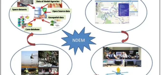
National Database for Emergency Management (NDEM) Services in Tackling Disasters
Towards supporting country’s efforts in efficient management of natural disasters, ISRO has evolved a comprehensive space-based Disaster Management Support (DMS) Programme and institutionalised the same in association with concerned ministries
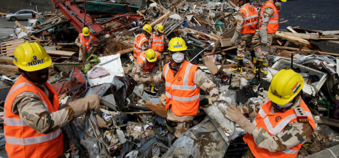
NDRF Joins Hands with ISRO to Get Real-time Satellite Data for Disaster Rescue
In a bid to obtain the vital “third eye” to tackle disasters, the National Disaster Response Force (NDRF) has inked a pact with the National Remote Sensing Centre (NRSC) which

3D Maps of Buildings to Improve Disaster Management Plans
India – In order to improve disaster management plans, the Gurgaon administration has decided to prepare 3D maps of 100 buildings in the city, including office complexes and hospitals. Gurgaon

Disaster Management Plan for Chennai to be Ready Soon
According to recent news by The Hindu, the Commissioner of Revenue Administration in association with Chennai Corporation and Chennai district collectorate will work together on disaster management. Chennai is yet

NIDM Emphasizes On the Need of Digital Mapping
In recent news by ToI, ahead to the planning of Kumbh Mela in Nashik, the National Institute of Disaster Management (NIDM) has suggested digitised mapping of Nashik to create a

Improve Underground Utilities Management and Public Safety by 3D GIS
Developed by Supergeo Technologies, SuperGIS 3D Earth Server is going to support underground utilities management. The breakthrough tech enables administrators to comprehend the distribution of underground utilities that cannot be

Indian PM Announces Satellite for SAARC Nations
In recent news by Shanghai Daily , during the inaugural session of the 18th South Asian Association for Regional Cooperation (SAARC) in Kathmandu, Nepal, Indian Prime Minister Narendra Modi said the

ICPECDM ’14 – International Conference on Challenges in Disaster Management
ICPECDM ’14 – International Conference on Professional Engineers: Challenges in Disaster Management Sponsored by TEQIP-II SC 1.2 18th-19th December 2014 India is one of the most disaster prone countries of

Webinar: Integrated and Collaborative Geospatial Platform for Disaster Management
GIS provides an integrated platform for sharing data and applications for disaster management that supports all facets of Disaster Management including preparation, mitigation, response, recovery and rehabilitation. Find out how
