
Tag "Disaster"

TCarta Delivers Satellite-Derived Land/Sea Floor Surface Models for Caribbean Disaster Recovery
BRISTOL, United Kingdom, 17 April 2018 – TCarta, a global provider of marine geospatial products, has delivered pre- and post-disaster surface models for the Caribbean islands of Antigua and Barbuda

Trimble Launches Trimble Foundation
In Conjunction with International Women’s Day, Trimble Foundation Partners with Camfed to Support the Advancement of Females in Africa SUNNYVALE, Calif. March 8, 2018—Trimble (NASDAQ: TRMB) announced today that it

Insitu Flies ScanEagle UAS for Disaster Relief and Fire Suppression Missions
COSTA MESA, Calif., November 28, 2017 – Insitu Inc., a wholly-owned subsidiary of The Boeing Company, used its ScanEagle® unmanned aerial system (UAS) in assisting with several recent disaster recovery

UAV can be Effectively Used in Disaster Management: NDMA
New Delhi, Nov 7, 2017 (PTI) – Unmanned aerial vehicles (UAVs) can be effectively used in disaster management, the National Disaster Management Authority (NDMA) today said. “UAVs can provide high-resolution,

Disaster Management Authorities to Get a New Tool to Handle Tsunamis
According to recent news by the First Post, Disaster management authorities are all set to get a new tool to handle tsunamis. They will be able to know how far the
Brainnwave Makes Data Available to Support Disaster Relief
September 12, 2017 – Brainnwave believe that people make better decisions if they have quick and simple access to the data they need, at the time they need it. With
Facebook Launches Disaster Maps to Help Communities Recover and Rebuild
According to recent news by the Facebook Newsroom, Facebook is introducing disaster maps that use aggregated, de-identified Facebook data to help organizations address the critical gap in the information they often
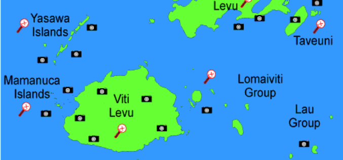
Fiji Adopted GIS to Help in Improving Natural Disaster Risk Development
According to the recent news reported by The Fiji Times Online, the office of the Commissioner Western will have access to information which will help in the visualization of the

NASA ARSET Online Remote Sensing Training Announcement: Overview of the Global Disaster Alert and Coordination System
NASA ARSET Online Remote Sensing Training Announcement: Overview of the Global Disaster Alert and Coordination System (GDACS) Dates: Tuesday, February 21, 2017 Times: 8:00-10:00 a.m. and 5:00-7:00 p.m. EST (UTC-5) Up-to-date

Fifteen Years of Disaster Relief From Space – Global Patterns and Trends
14 July 2016 – Today, the analysis and use of satellite images is commonplace. Just 15 years ago, however, only a handful of specialists worked with these valuable data. Since then,
