
Tag "Geospatial software"
Penn State University Launches New Graduate Certificate for Geospatial Software Developers
Certificate in geospatial programming and web map development being offered exclusively online through Penn State World Campus NIVERSITY PARK, Pa. – July 2, 2018 – Penn State has launched a

LISTECH Releases New Upgrade for Geospatial Software Neo
Melbourne, Australia, 28 November 2017 – LISTECH, a world leader in development of smart software solutions for the surveying, civil engineering and land related information industries today announced the latest
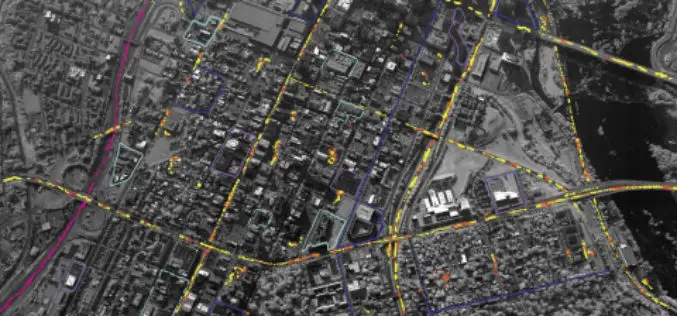
BAE Systems Enhances Geospatial Software by Adding Movement Intelligence Capabilities
SAN DIEGO–(BUSINESS WIRE)–BAE Systems has integrated capabilities called Movement Intelligence, or MOVINT, into its Geospatial eXploitation Products™ (GXP®) line of software, helping analysts to more easily identify intelligence threats using
Enhanced Imagery, Modelling, Volumes Improve Productivity With LISTECH Neo
LISTECH, a Hexagon Geosystems brand, today announced increased functionality to its new geospatial software Neo, with terrain modelling, volume calculation and imagery offerings. With an integrated 3D/2D environment for viewing

SAR Processing with Geomatica Training Course
Master Geomatica from the comfort of your own desk! 2015 Training Sessions on now! Course: SAR Processing in Geomatica Throughout the year our top instructors deliver expert training in a convenient
LizardTech Introduces National Universities Subscription Program
New program offers an enhanced learning platform for national university students around the globe LizardTech®, the creator of MrSID® and provider of software solutions for managing and distributing geospatial content,

Trimble to Provide Geospatial Software and Online Training for Post-Graduate Distance Learning Programs
Trimble to Provide Geospatial Software and Online Training for Post-Graduate Distance Learning Programs with UNIGIS International Supporting Continuing Education in Geographic Information Systems (GIS) SUNNYVALE, Calif.,Oct. 16, 2015- Trimble (NASDAQ: TRMB) and

SAR Processing in Geomatica – Online Training
SAR processing in Geomatica is an advanced course that explores data preparation, processing and analysis techniques for working with Synthetic Aperture Radar (SAR) data. In this 3-day course, participants will
