
Tag "remote sensing satellite"

Pakistan to Launch First Remote Sensing Satellite by 2018
Islamabad [Pakistan], According to recent news by the ANI, with space technology being used in the planning and monitoring of China-Pakistan Economic Corridor (CPEC) projects, the Pakistan Space and Upper

Gaofen-4 – China’s First High Orbit Remote Sensing Satellite Put Into Use
PTI- China’s first high orbit remote sensing satellite, Gaofen-4, said to be the world’s most sophisticated, became operational after six months in-orbit testing, it was announced today. Gaofen-4 is China’s
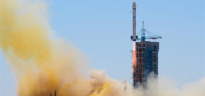
China Launches Yaogan-30 Remote Sensing Satellite
According to recent news by Xinhua, China has successfully launched Yaogan-30 remote sensing satellite into space. The spacecraft lifted off at 10:43 a.m. local time Sunday, May 15 (10:43 p.m. EDT
Pakistan Inked Contract with China to Develop First Remote Sensing Satellite
According to recent news by The Nation, Pakistan Space & Upper Atmosphere Research Commission (SUPARCO) and China Great Wall Industry Cooperation (CGWIC) signed a contract on Wednesday for the development and

Second Belarusian Remote Sensing Satellite in Orbit in 2019
MINSK, 7 April (BelTA) – The Belarusian satellite BKA-2 is supposed to be inserted into an orbit around the Earth in 2019, BelTA learned from Sergei Zolotoi, Chief Designer of

Iran and APSCO Jointly to Build a Remote Sensing Satellite
According to recent news by the Trend New Agency, Iran and seven member states of the Asia-Pacific Space Cooperation Organization (APSCO) are negotiating to jointly design and build a remote sensing
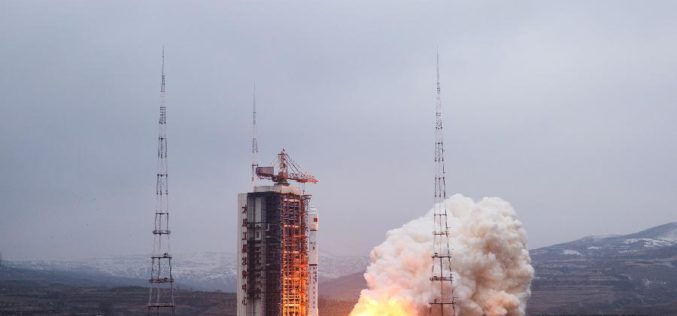
China Launches Yaogan-28 Remote Sensing Satellite from Taiyuan
China on Sunday successfully launched its latest remote sensing satellite to be used for experiments, land surveys, crop yield estimates and disaster relief. The satellite named Yaogan-28 was carried by a

China to Set Up 3 Civil Satellite Systems By 2020
BEIJING – China aims to finish building satellite systems for remote sensing, communications and navigation before 2020. The three satellite systems should be able to provide continuous and stable service,

China Launches Tianhui-1 Remote Sensing Satellite
Beijing: China has successfully sent its third mapping satellite of the Tianhui-1 series into orbit on Oct. 26, 2015. Tianhui-1 will enhance the country’s ability to carry out scientific research, mapping and disaster
Belarus and Russia Partners to Define Specifications for a New Belarusian Remote Sensing Satellite
According to recent new by Sputnik, Belarus and Russia has joined their hands to announce technical specifications for a new Belarusian remote sensing satellite. President of the Belarusian Academy of Sciences Vladimir
