
Tag "Vietnam"

GIS
Vietnam: GIS to Prevent Infectious Diseases
According to recent news by the Vietnam Bridge, the Ho Chi Minh City (HCM) of Vietnam has decided to promote its geographic information system (GIS), to prevent infectious diseases. The statement was
GIS
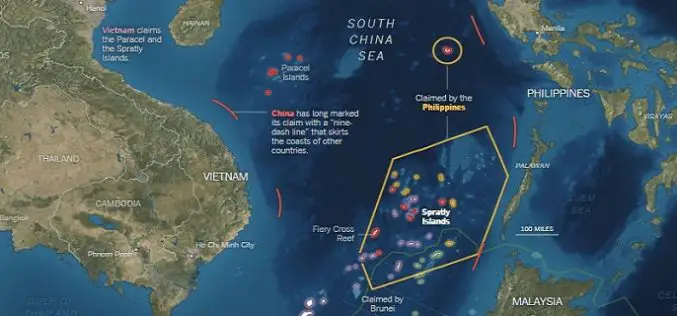
What’s Drives China in the South China Sea? A GEOINT View
Contributed By: The Spratly Islands are a group of more than 750 reefs, islets, atolls, cays and islands in the South China Sea. The history of territorial claim on these

GIS
India and Vietnam to Cooperate in Earth Observation Technology
In a recent visit by the delegation of the Vietnamese ministry to India, a joint decision between India’s Ministry of External Affairs, Department of Space, and Space Research Organisation and

Remote Sensing
Vietnam to Use Remote Sensing in Agriculture
In recent news, Vietnam is gearing up to use Remote Sensing to boost its agricultural production. In a conference last week Le Quoc Doanh, Deputy Minister of Agriculture and Rural
