Urban Surface Temperature Time Series Estimation at the Local Scale by Spatial-Spectral Unmixing of Satellite Observations

Urban Surface Temperature Time Series Estimation at the Local Scale by Spatial-Spectral Unmixing of Satellite Observations
– Zina Mitraka, Nektarios Chrysoulakis, Georgia Doxani, Fabio Del Frate and Michael Berger
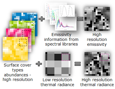 Abstract: The study of urban climate requires frequent and accurate monitoring of land surface temperature (LST), at the local scale. Since currently, no space-borne sensor provides frequent thermal infrared imagery at high spatial resolution, the scientific community has focused on synergistic methods for retrieving LST that can be suitable for urban studies. Synergistic methods that combine the spatial structure of visible and near-infrared observations with the more frequent, but low-resolution surface temperature patterns derived by thermal infrared imagery provide excellent means for obtaining frequent LST estimates at the local scale in cities. In this study, a new approach based on spatial-spectral unmixing techniques was developed for improving the spatial resolution of thermal infrared observations and the subsequent LST estimation. The method was applied to an urban area in Crete, Greece, for the time period of one year. The results were evaluated against independent high-resolution LST datasets and found to be very promising, with RMSE less than 2 K in all cases. The developed approach has therefore a high potential to be operationally used in the near future, exploiting the Copernicus Sentinel (2 and 3) observations, to provide high spatio-temporal resolution LST estimates in cities.
Keywords: land surface temperature; local scale; urban surface emissivity; urban climate; spatial-spectral unmixing; downscaling
Download Paper in PDF