EarthDefine, a provider of high-resolution geospatial spatial data that uses artificial intelligence (AI) to analyze aerial and LIDAR imagery, today announced the release of an updated building footprint database, which contains over 156 million footprints of commercial and residential structures across the continental United States. EarthDefine’s latest update will allow insurers to identify with rooftop accuracy where structures fall within a parcel of land to improve risk rating, quoting accuracy, and claims response.
EarthDefine’s building footprints are generated using state-of-the-art deep neural networks. Neural networks are a type of artificial intelligence (AI) algorithm that can provide accurate extraction of ground features like building footprints, parking lots, trees, swimming pools, solar panels, etc., from aerial imagery and LIDAR data across large scales and highly diverse geography. This AI-based approach is extremely accurate (98% accuracy) and allows EarthDefine to continually grow its building footprint database to create an updated snapshot of commercial and residential properties throughout the continental United States.
In addition to its building footprints, EarthDefine can also generate the following property attributes on-demand to help insurers make better and more accurate risk-based decisions:
- Distance to Power Lines
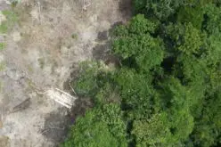
- Tree Canopy & Tree Locations
- Ground Elevation
- Land Cover
- Building Heights
- Swimming Pools
- Building Change Detection
- Parking Lots
- And More
“We’re extremely happy that we could get our latest geocoding and tree canopy update released so we could assist P&C insurers when they need it the most, said Vikalpa Jetly, CEO & Founder, EarthDefine. “According to NOAA, as of July 8, 2020, there have already been ten billion-dollar weather disasters in the United States. In order for insurers to truly understand the impact of wildfires and other severe weather events, they need to be able to take an address and pinpoint its exact location on a map. Once a policy’s location has been correctly geocoded, then insurers can begin their location analysis. One of the benefits of our building footprint update is that insurers can now take an address and not only pinpoint the primary and secondary structures within a parcel of land, they can also tie in vital property data, such as tree locations, land cover, and distance to power lines to gain a better understanding about the impact of wildfires. This information can then be used by insurers to work with agents and insureds to take proactive measures like creating more defensible space or clearing brush next to combustible materials,” said Jetly.
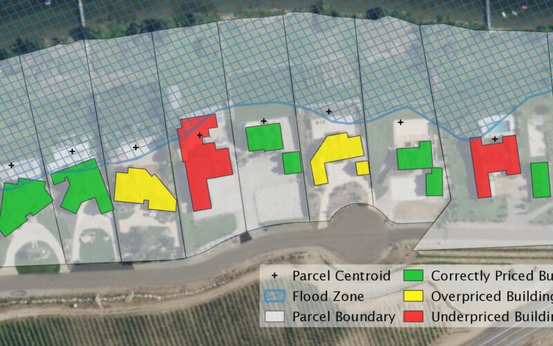
EarthDefine’s building footprints are the latest generation of geocoding solutions, which have evolved from zip code based centroids to street interpolated geocoding and, most recently, parcel-level geocoding. While these forms of geocoding may generate useful insights, they are also flawed because they are based upon assumptions on where properties are located on a map. For example, with parcel-level geocoding, addresses are always mapped to the center of a parcel. This poses a problem because parcels often vary in size, so if a policy is located in the upper northeast corner or lower southwest corner, then a carrier will be basing their wildfire, flood, hurricane, hail, etc., determinations on the wrong location. This can quickly lead to stacking errors where hundreds or even thousands of addresses in a book of business may be incorrectly geocoded, leading insurers to suffer higher losses than anticipated.
EarthDefine’s building footprints may be accessed as flat files or via REST API and will benefit MGAs, Carriers, and Reinsurers throughout the insurance cycle by:
- Reducing post bind adjustments by identifying the correct location of an address during the time of quote
- Eliminating fraudulent claims payouts by validating addresses during FNOL
- Improving catastrophe modeling accuracy by pinpointing the exact locations of policyholders’ addresses
- Uncovering high-risk locations and working with agents and insureds to mitigate potential issues
- Reducing underinsurance by identifying secondary structures within a parcel of land
- And much more
Insurance carriers, MGAs, and reinsurers who write in the western and southern regions of the United States may request a free trial by contacting Vikalpa Jetly, CEO & Founder, EarthDefine at data@earthdefine.com or 1.800.579.5916.
About EarthDefine
EarthDefine is using AI to transform earth sensor data into consumable geospatial information products. To learn more please visit: www.earthdefine.com
Also Read –