TorchGeo 0.6 marks a significant step forward in geospatial machine learning by offering new datasets, data modules, and pre-trained models for satellite image analysis. Over 11 months, 23 contributors worked on this update, which introduces groundbreaking tools for deep learning applications in Earth observation.
TorchGeo’s integration with Microsoft, specifically through the PyTorch ecosystem, enhances its power. Microsoft supports PyTorch, the deep learning framework that TorchGeo is built on.
Background and Purpose
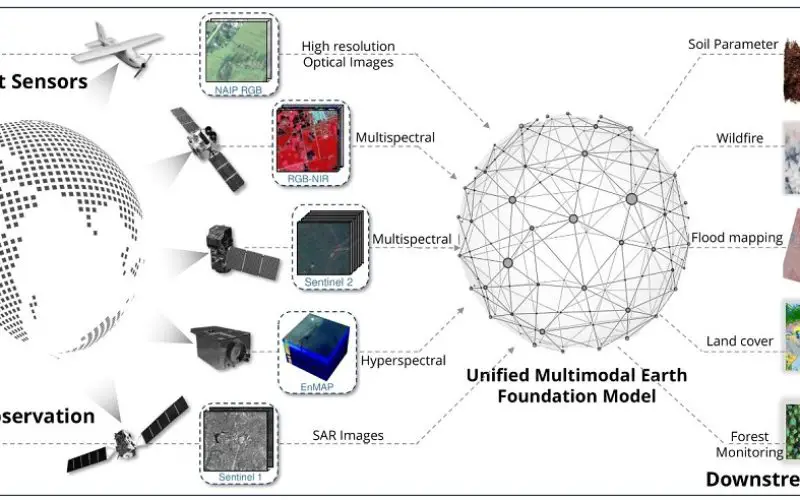
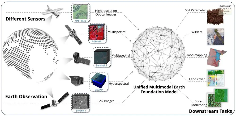
The growing need for geospatial machine learning is driven by the thousands of satellites orbiting Earth, capturing vast amounts of data. Traditionally, deep learning models required millions of manually labeled images from specific satellite sensors to function effectively. Even self-supervised learning, which eliminates the need for labels, still demanded a large volume of sensor-specific images. This posed challenges for using newly launched or commercial satellites.
TorchGeo 0.6 solves these problems by providing models that can work with any satellite imagery, regardless of whether the model was trained on it. This makes it more accessible and flexible, particularly for newly launched or expensive sensors.
Also read – Machine Learning to Discover Shell Rings Using Remote Sensing Data
Uses of TorchGeo 0.6
TorchGeo 0.6 brings advanced capabilities for geospatial machine learning through new multimodal and unimodal foundation models:
- DOFA: Supports RGB, SAR, MSI, and HSI imagery, making it adaptable for multiple satellite sensors. Its wavelength-based encoder ensures accurate spectral mapping, providing better insights across different types of data.
- GASSL and Scale-MAE: Focus on RGB image data, with Scale-MAE specifically supporting spatial resolution for more detailed image analysis.
These models can be applied to a wide range of geospatial machine learning tasks, from environmental monitoring to urban planning and disaster response.
TorchGeo 0.6 also adds multiple new unimodal foundation models, including DeCUR and SatlasPretrain.
Click her to download datasets and modules of TorchGeo 0.6.0 from Github.
Benefits of TorchGeo 0.6
TorchGeo 0.6 makes it easier for developers and researchers to use satellite data without needing labeled datasets. Its self-supervised learning models simplify data analysis, saving time and resources. Additionally, the compatibility with multiple sensors means the models can work with various satellite images, even those from newly launched or commercial satellites. The Microsoft partnership also ensures scalability, making TorchGeo ideal for handling the extensive datasets common in geospatial machine learning.
Conclusion
TorchGeo 0.6 represents a leap forward for geospatial machine learning. Its new models, datasets, and modules empower users to efficiently analyze satellite data across various applications. Whether you are in environmental research, disaster response, or urban development, TorchGeo 0.6 provides a powerful tool for satellite imagery analysis.
Explore its features and share your experiences in the comments. Your insights could shape the future of geospatial data analysis. Don’t forget to like, share, and engage with this article to stay updated on the latest in geospatial machine learning!


