
Business
HERE to Acquire Global Indoor Maps Provider Micello
Santa Clara, CA – January 24, 2018 – HERE Technologies today announced that it has signed a definitive agreement to acquire Micello, a privately held software company based in California
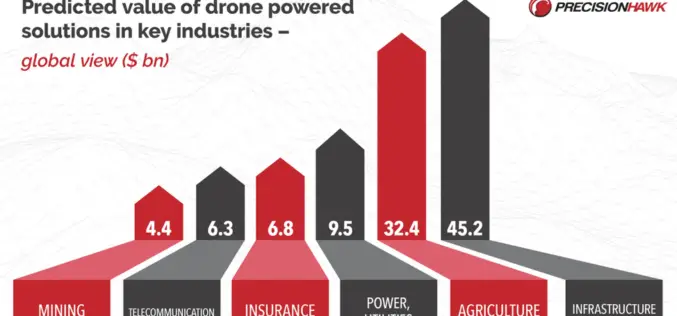
PrecisionHawk Secures $75 Million to Foster Global Adoption of Commercial Drone Technology
Raleigh, NC – January 24, 2018 – PrecisionHawk, Inc. – a leading provider of drone technology for the enterprise – announced today it has raised a $75 million round of
GeoCalc SDK 7.4 Update Includes Support for New Projections and JSON Wrapper Classes for Calling to GeoCalc Cloud
Hallowell, Maine – January 23, 2018 – Blue Marble Geographics (bluemarblegeo.com) is pleased to announce the immediate availability of version 7.4 of the GeoCalc Software Development Kit (SDK). This powerful toolkit
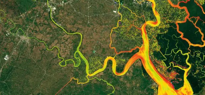
DLR Spin-off EOMAP Launches an Online Portal for UNESCO Programme on Global Indicator of Water Quality
Worldwide mapping of water quality data for all inland and coastal waters is now possible for the first time thanks to satellite data. Using high-resolution remote sensing data, EOMAP has
Esri Releases World’s First Complete Utility GIS Platform
New Utility Network Management Extension Combines Advanced System of Record with Location-Based Analytics Redlands, California – January 22, 2018 – Esri, the global leader in geographic information system (GIS) technology and spatial analytics,
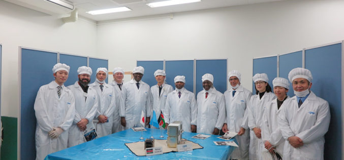
The University of Nairobi Hands the First KiboCUBE CubeSat over to JAXA Under UNOOSA-JAXA KiboCUBE Programme
January 19, 2018 – On January 16, 2018, at the JAXA Tsukuba Space Center, the team from the University of Nairobi handed over to JAXA their first KiboCUBE CubeSat, 1KUNS-PF

thinkWhere Takes a Global View with theMapCloud Platform
Stirling, Scotland, January 17, 2018 – Scottish Geographic Information Systems (GIS) company thinkWhere is setting its sights on global expansion with the launch of a new cloud-based platform for GIS and

4DGlobal to Provide Applanix Products and Solutions for Land and Air Survey Customers in Australia and New Zealand
Applanix, a Trimble Company (NASDAQ: TRMB), announced today that 4DGlobal has been selected to provide products, support, and service for Applanix’ air and land customers in Australia and New Zealand.

South Korea Agency for Defense Development Selects SimActive
January 16, 2018 – SimActive is pleased to announce that the Republic of Korea Agency for Defense Development (ADD) has selected Correlator3D™. Their use of the software will include processing
HERE Supports Baidu With Indoor Maps
January 11, 2018, Las Vegas – HERE Technologies, a global leader in mapping and location services, today announced that it will broaden its collaboration with Baidu to power Baidu Maps with indoor
