Surveying provided the basis for man to know ‘what is where’ and ‘when’. The technology, if we can call it a technology during the early 19th century, was able to provide two very precious parameters – distance, which was deduced by determining angle and location on the earth, and time, which was obtained by observing the sun and the stars in the sky. This remarkable technology laid the foundation of what we know now as the Geospatial Technology.
And Forensic investigations still want to determine ‘what incident happened where’ and ‘when’ in order to find the reason for the incident and who, if any or applicable, was responsible.
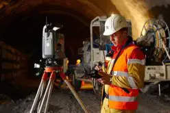
With the evolution of technologies, we now use sophisticated and easy to use equipments such as the digital survey technologies that include smartphones, tablets, digital cameras that are all integrated with the global positioning system (GPS) navigation systems that provide location and time of an incident. Sophisticated space based technologies now provide imagery that capture digital images over a small or wide area as a record of the spatial and spectral information of an incident. All this information is combined in sophisticated softwares that are run on powerful hardware that provide models to evaluate an incident or provide realistic scenarios for decision makers to establish the facts of the incident.
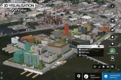
Forensic investigations have become have, over the years, evolved into their own specialised domains, such as, Forensic geography, Geoforensics or Forensic geosciences, Forensic mapping, Environmental forensics, Forensic GIS, Forensic Archaeology etc. By using sophisticated Geospatial technologies, data can be captured and analysed interactively by switching between different perspectives that can rotate around illustrations to throw up different theories as well as combined with statistics to provide better clarification and visualisation of an incident.
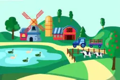
Up-to-date and detailed databases can be prepared to compare with similar incidents in the past. Forensic GIS and Geospatial Modelling of the different parameters, available in separate incidents, can provide investigators with as insight to a particular incident. Before and after scenarios can be generated to study different aspects of an incident and are especially useful in investigating the effects of natural disasters.
Geospatial technologies combined with imageries and modelling software are an established tool in the hands of a forensic investigator that aid him in the establishing facts of an incident in order to arrive at decisions and data that can be used by a court of law or an insurance agency or to improve upon a hypothesis in the scientific community or to help recover valued remains and artefacts etc.
Geospatial technologies are now an essential component of digital forensics.