
Research Papers

NASA ARSET – Remote Sensing Training: Methods & Best Practices
Remote Sensing Training: Methods & Best Practices Thursdays, October 13-27, 2016 10:00 – 11:30 a.m. and 5:00 – 6:30 p.m. EDT (UTC-4) The goal of the NASA Applied Remote Sensing
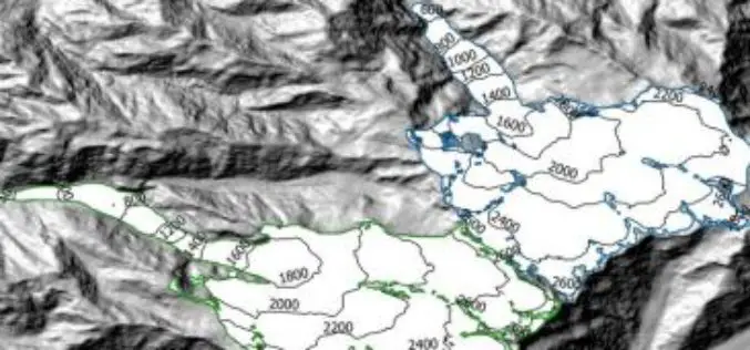
Modeling Glacier Elevation Change from DEM Time Series
Modeling Glacier Elevation Change from DEM Time Series – Wang, D.; Käb, A. Modeling Glacier Elevation Change from DEM Time Series. Remote Sens. 2015, 7, 10117-10142. Abstract: In this study, a methodology for
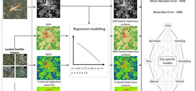
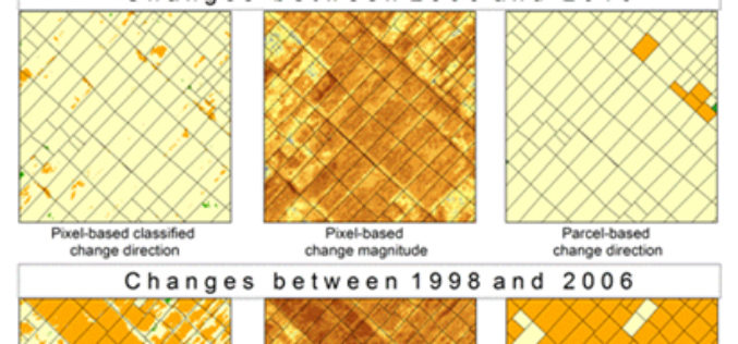
Using Landsat Vegetation Indices to Estimate Impervious Surface Fractions for European Cities
Using Landsat Vegetation Indices to Estimate Impervious Surface Fractions for European Cities – Kaspersen, P.S.; Fensholt, R.; Drews, M. Using Landsat Vegetation Indices to Estimate Impervious Surface Fractions for European Cities.
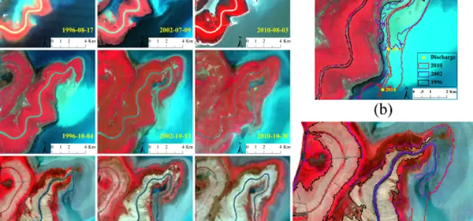
Monitoring Spatial and Temporal Dynamics of Flood Regimes and Their Relation to Wetland Landscape Patterns in Dongting Lake from MODIS Time-Series Imagery
Monitoring Spatial and Temporal Dynamics of Flood Regimes and Their Relation to Wetland Landscape Patterns in Dongting Lake from MODIS Time-Series Imagery – Hu, Y.; Huang, J.; Du, Y.; Han, P.;
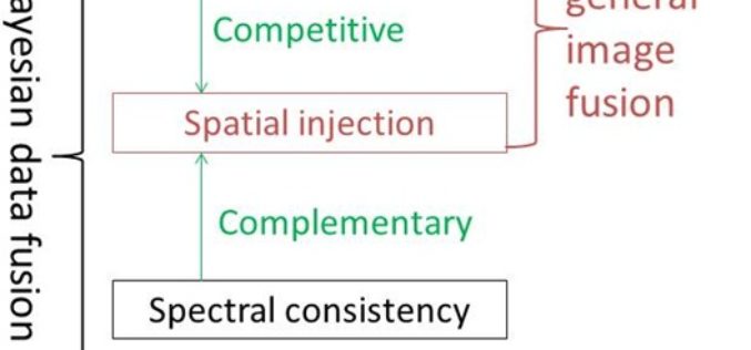
A New Look at Image Fusion Methods from a Bayesian Perspective
A New Look at Image Fusion Methods from a Bayesian Perspective – Hankui K. Zhang and Bo Huang Abstract: Component substitution (CS) and multi-resolution analysis (MRA) are the two basic categories in the
SPOT-Based Sub-Field Level Monitoring of Vegetation Cover Dynamics: A Case of Irrigated Croplands
SPOT-Based Sub-Field Level Monitoring of Vegetation Cover Dynamics: A Case of Irrigated Croplands – Olena Dubovyk, Gunter Menz, Alexander Lee, Juergen Schellberg, Frank Thonfeld and Asia Khamzina Abstract: Acquiring multi-temporal spatial information on vegetation condition
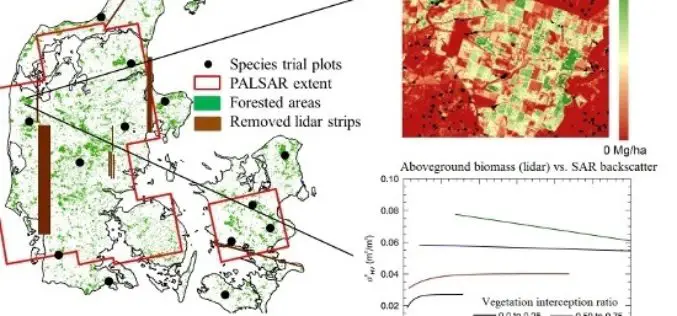
L-Band SAR Backscatter Related to Forest Cover, Height and Aboveground Biomass at Multiple Spatial Scales across Denmark
L-Band SAR Backscatter Related to Forest Cover, Height and Aboveground Biomass at Multiple Spatial Scales across Denmark – Neha P. Joshi, Edward T. A. Mitchard, Johannes Schumacher, Vivian K. Johannsen, Sassan Saatchi and
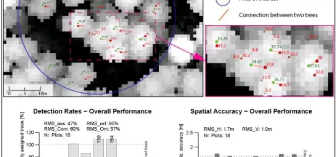
A Benchmark of Lidar-Based Single Tree Detection Methods Using Heterogeneous Forest Data from the Alpine Space
A Benchmark of Lidar-Based Single Tree Detection Methods Using Heterogeneous Forest Data from the Alpine Space – Lothar Eysn, Markus Hollaus, Eva Lindberg, Frédéric Berger, Jean-Matthieu Monnet, Michele Dalponte, Milan Kobal, Marco Pellegrini, Emanuele
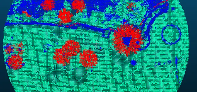
Forest Canopy LAI and Vertical FAVD Profile Inversion from Airborne Full Waveform LiDAR Data Based on a Radiative Transfer Model
Forest Canopy LAI and Vertical FAVD Profile Inversion from Airborne Full Waveform LiDAR Data Based on a Radiative Transfer Model – Han Ma, Jinling Song and Jindi Wang Abstract: Forest
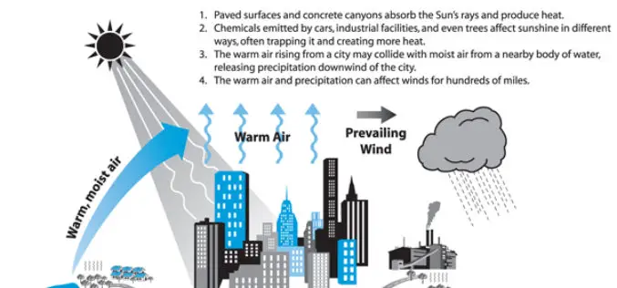
Analysis of the Urban Heat Island Effect in Shijiazhuang, China Using Satellite and Airborne Data
Analysis of the Urban Heat Island Effect in Shijiazhuang, China Using Satellite and Airborne Data – Kai Liu, Hongbo Su, Lifu Zhang, Hang Yang, Renhua Zhang and Xueke Li Abstract: The urban heat island (UHI)
