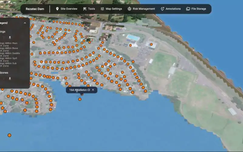
Rezatec has launched a groundbreaking solution for dam operators with its enhanced geospatial AI platform for dam monitoring. This cutting-edge platform is set to transform how dam safety and risk management are approached, integrating satellite data with powerful AI analytics to create a holistic view of potential risk awareness.
The geospatial AI for dam monitoring platform centralizes dam record management by digitizing all critical dam information. This includes data on ground motion, seepage, and downstream hazards. Using satellite imagery, the platform can detect millimetric changes in terrain and vegetation that could signal emerging issues. This method of continuous, year-round monitoring bridges the gap between manual inspections, offering an unprecedented level of risk.
Also Read – Designing A Dam Monitoring System. Pg. No. 12
Published in GIS Resources Magazine – Geospatial Technologies For Construction and Monitoring
Revolutionizing Risk Management
One of the most significant innovations of this solution is its capacity to provide dynamic risk assessments using advanced AI models. The platform can analyze vast amounts of data, identifying failure modes and alerting dam operators to potential hazards long before they become critical issues. This combination of AI and geospatial technology delivers timely insights that enhance decision-making for dam operators and regulators.
The new release includes four core modules that address compliance, ground motion and seepage, downstream hazards, and overall risk management. For instance, the Ground Motion & Seepage module leverages satellite data to track unusual changes in ground movement and seepage, enabling operators to take preemptive action. This ensures that dam safety is consistently monitored and that decision-makers can react swiftly to early warning signs.
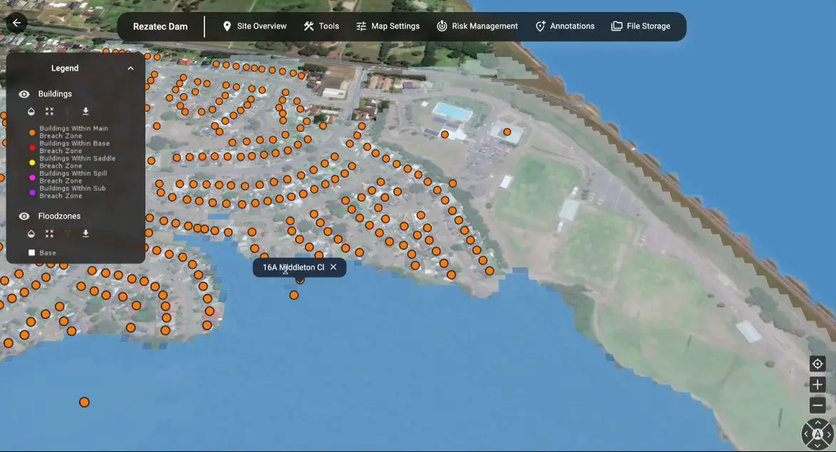
Downstream Hazard Monitoring
The platform also features enhanced downstream hazard monitoring. It identifies any significant changes in flood zones that may affect dam safety, reducing the manual effort required to collect such data. This feature supports emergency planning and ensures the ongoing safety of nearby communities. By consolidating these crucial data points, geospatial AI for dam monitoring makes it easier to manage hazards efficiently and systematically.
AI-Powered Safety Management
At the heart of this solution is the Risk Management module, which uses a unique matrix to assess the likelihood and consequences of various dam failure scenarios. The platform’s AI capabilities bring powerful insights, helping operators prioritize risks and allocate resources effectively. As Daniel Turnbull, a dam safety engineer at Hunter Water, remarks, Rezatec’s platform empowers them to exceed regulatory requirements and safeguard infrastructure and communities.
A New Era in Infrastructure Monitoring
Rezatec’s geospatial AI platform represents a new era in infrastructure monitoring, where data-driven insights and AI-powered tools drive decision-making. This technology is not just about keeping dams safe; it provides an adaptable, scalable solution for infrastructure monitoring across industries.
As the platform evolves, geospatial AI will continue to be an integral part of ensuring the safety of critical infrastructure like dams, reservoirs, and levees. With such advances, the future of geospatial AI for dam monitoring looks promising, ensuring safer and more resilient infrastructure management globally.
Source: Rezatec