The Telangana government has initiated the One Map Hyderabad project, a large-scale LiDAR survey aimed at improving urban planning and infrastructure management. This project will consolidate critical urban data, such as road networks, electricity supply, water distribution, sewage systems, and emergency services, into a high-resolution digital platform. By integrating this data, the government seeks to streamline city governance, optimize resource allocation, and improve public services.
Comprehensive Coverage and Advanced Technology
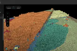
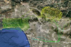
Chief Minister A. Revanth Reddy has directed the survey to cover the entire Greater Hyderabad Municipal Corporation (GHMC) region and extend up to the Outer Ring Road (ORR), spanning approximately 2,050 square kilometers. LiDAR, which stands for Light Detection and Ranging, is a cutting-edge remote sensing technology that utilizes laser pulses to measure distances and create highly detailed topographical data. Compared to traditional drone-based surveys, LiDAR provides superior accuracy, capturing intricate details of terrain, elevation, and built structures.
Also Read – LiDAR Technology Uncovers Hidden Silk Road Cities in Uzbekistan
Enhancing Urban Planning with One Map Hyderabad
Previously, the GHMC conducted a GIS-based drone survey covering 625 square kilometers to assess unregistered properties and improve revenue collection. However, One Map Hyderabad aims to go beyond property assessment by creating a comprehensive geospatial database. This data will help government agencies with disaster management, land-use planning, infrastructure monitoring, and traffic management. Additionally, the project will assist in identifying unauthorized constructions and improving emergency response strategies.
Project Timeline and Implementation
The municipal administration and urban development department are finalizing the tendering process, and survey operations will begin soon. Mapping of the GHMC area is expected to be completed within six months, while mapping of the ORR region will conclude by the end of the year. The gathered data will be integrated into a centralized digital platform, allowing seamless access for various departments involved in urban planning and development.
Future Impact and Smart City Vision
The One Map Hyderabad initiative is set to transform city governance by providing high-resolution geospatial data for better decision-making. This technology will streamline construction approvals, monitor urban expansion, and enhance public services like waste management and utility distribution. The government is also considering a mobile application that will allow both officials and the public to access real-time infrastructure data, fostering transparency and civic engagement.
As Hyderabad continues to expand, accurate geospatial data will play a crucial role in sustainable urban development. By leveraging LiDAR technology, One Map Hyderabad positions the city for smarter, data-driven governance, ensuring efficient urban planning and better living conditions for its residents.
Source: Prop News Time