ISRO Satellite Monitoring Projects 122.7 Million Tonnes of Wheat for Rabi 2024-25

In a significant stride towards enhancing agricultural productivity, the Indian Space Research Organisation (ISRO) has developed a semi-automated framework for real-time monitoring of wheat crops across major Indian states. This initiative aims to provide accurate assessments of crop sowing and harvesting patterns during the 2024-25 Rabi season.
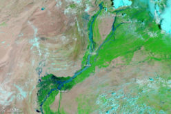
The framework, known as Comprehensive Remote Sensing Observation on Crop Progress (CROP), utilizes optical and synthetic aperture radar datasets from multiple satellites to systematically assess wheat sown areas and overall crop conditions. The monitoring focuses on eight major wheat-growing states: Uttar Pradesh, Madhya Pradesh, Rajasthan, Punjab, Haryana, Bihar, Gujarat, and Maharashtra.
As of March 31, 2025, satellite data analysis indicates that the wheat sown area stands at 330.8 lakh hectares, closely aligning with the Ministry of Agriculture & Farmers Welfare’s statistics of 324.4 lakh hectares reported on February 4, 2025. This near real-time monitoring capability is a testament to the accuracy and efficiency of ISRO’s satellite-based assessments.
Also Read – How CropSmart Digital Twin is Revolutionizing Precision Agriculture
The framework employs a remote sensing-based Vegetation Health Index (VHI) to evaluate crop conditions and potential drought stress. In January, crop conditions were stable with timely sowing and satisfactory growth, particularly in Punjab, Haryana, and Uttar Pradesh. However, February witnessed rising temperatures and rainfall deficits, raising concerns about potential yield losses due to heat stress during grain filling stages. By late March, favorable weather conditions contributed to the resilience of Rabi crops, leading to optimistic projections.
An experimental assessment integrating satellite-derived parameters with a process-based crop growth simulation model at a 5 km × 5 km spatial resolution estimates total wheat production from the eight major wheat-growing states at 122.7 million tonnes as of March 31, 2025. This methodology showcases the potential for near real-time monitoring of crop areas using multi-source satellite data, highlighting its applicability for operational scalability in agricultural planning and food security decision-making at the national level.
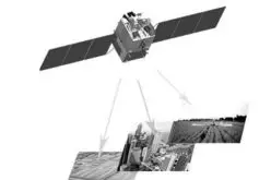
ISRO’s advancements in satellite technology, including the development of dedicated satellites for the agricultural sector, underscore the organization’s commitment to supporting India’s farming community. These initiatives aim to provide continuous observation capabilities, aiding in crop forecasting, pesticide application, irrigation, soil data analysis, and drought assessment. The integration of such technologies is poised to transform India’s agricultural landscape, ensuring sustainable and efficient farming practices.
Source: The Hindu