
Courses
2016 ESA Earth Observation Summer School
European Space Agency (ESA) organises a series of summer schools on Monitoring of the Earth System to promote the exploitation of EO data across disciplines, with a specific focus on
Bhuvan – Training Explaining the Functionalities and Utilities of Bhuvan
Training is offered on Bhuvan Visualization, Services and Collaborative Applications. In order to increase the awareness on Bhuvan, attract Academicians to participate in crowdsourcing & development and initiate Government agencies

Applied Geodesy & Geographic Calculator Public Training
Applied Geodesy & Geographic Calculator Public Training This one day session covers the foundations and principles of Geodesy and mapping. Whether you’re an expert in GIS or just starting out,
PhD Studentship in Hyperspectral Remote Sensing
Cranfield University is a British postgraduate and research-based university specialising in science, engineering, technology and management. It contains two campuses; the main campus is at Cranfield, Bedfordshire, and the second is the
UN Certificate Course on Geospatial Technologies for Disaster Risk Reduction
Geospatial Technologies for Disaster Risk Reduction in the Horn of Africa Geographic information systems (GIS) can be a very useful tool for the whole disaster management cycle starting from the
5th EnMAP School on Hyperspectral Remote Sensing
The EnMAP Science Advisory Group (EnSAG) organizes the 5th EnMAP School at Trier University in April 2016. We are pleased to host the EnMAP School in Trier for the second

SAR Processing with Geomatica Training Course
Master Geomatica from the comfort of your own desk! 2015 Training Sessions on now! Course: SAR Processing in Geomatica Throughout the year our top instructors deliver expert training in a convenient
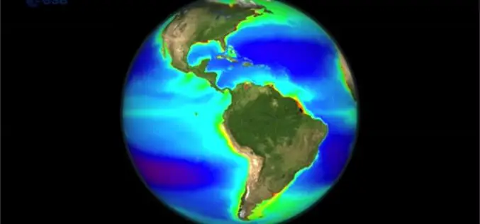
Learn the Basic about Monitoring Climate from Space
Seeing the Earth from space allows us to gain this global perspective. By using Earth observation techniques, we can now monitor global environmental change on a scale that has never
PhD Candidate on Remote Sensing Based Characterization of Functional Diversity in Polar Regions
Leiden University (founded in 1575) is one of Europe’s leading international research-intensive universities. This prominent position gives our graduates an advantage when applying for positions both within and outside the
Join Free Training on Bhuvan – Gateway to Geospatial World
Training on Bhuvan – Gateway to Geospatial World December 08 – 09, 2015 Bhuvan, (lit: Earth), is a software application which allows users to explore a 2D/3D representation of the
