Revolutionizing Rural India: Geospatial Innovations with Gram Manchitra

The Ministry of Panchayati Raj in India has introduced several digital initiatives to support spatial planning and improve transparency in local village councils, known as Gram Panchayats. One key initiative is the Geographic Information System (GIS) application, “Gram Manchitra“.
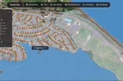
This application enables Gram Panchayats to utilize geospatial technology for effective planning, providing a unified platform to visualize various developmental works and offering a decision support system for the Gram Panchayat Development Plan (GPDP).
Additionally, the Ministry launched mActionSoft, a mobile-based solution for capturing photos with Geo-Tags (GPS coordinates) of assets at three stages: before the start of work, during the work, and upon completion. This tool creates a repository of information on assets related to natural resource management, water harvesting, drought proofing, sanitation, agriculture, check dams, and irrigation channels. These geotagged assets are integrated into Gram Manchitra, enhancing the visualization of developmental projects.
Panchayats geotag assets funded by the finance commission, with GIS data and photographs available on Gram Manchitra. The application provides planning tools using GIS technology to help officials develop realistic development plans, including tools for site identification, asset tracking, cost estimation, and impact assessment.

Under the Digital India Programme, the Ministry implements the e-Panchayat Mission Mode Project (MMP), aiming to make Panchayats more transparent, accountable, and effective. Launched on April 24, 2020, eGramSwaraj is a comprehensive application for Panchayats, encompassing planning, budgeting, accounting, monitoring, and asset management on a single digital platform, including online payments. So far, 2.44 lakh Gram Panchayats have uploaded their GPDPs for 2024-25, and 2.06 lakh Panchayats have completed online transactions for the 15th Finance Commission grants for 2024-25.
To strengthen transparency, the Ministry rolled out AuditOnline under the e-Panchayat MMP, facilitating online audits of Panchayat accounts. For the audit year 2022-23, 2.52 lakh Audit Plans were created, and 2.48 lakh Audit Reports were generated.
The BharatNet project, implemented by the Department of Telecommunications, aims to connect all Gram Panchayats via broadband. As of now, 2.17 lakh Gram Panchayats are service-ready. Additionally, 2.32 lakh Gram Panchayats across 31 States and UTs have conducted Gram Sabha (village meetings), and 2.15 lakh have finalized their Citizen Charters.
This information was provided by the Union Minister of State for Panchayati Raj, Prof. S. P. Singh Baghel, in a written reply in Lok Sabha, the lower house of India’s Parliament.


