
Business

Marcos Garcia of RIEGL Asia Pacific Attends 91st ASEAN Flag Council Meeting
Marcos Garcia, Managing Director of RIEGL Asia Pacific, attended the 91st ASEAN Flag Council Meeting to officially receive the certificate of corporate membership of the ASEAN Federation of Land Surveying

The 2nd MENA Geospatial Forum 2025 Opens with Strong Industry Engagement, Advancing Regional Geospatial Innovation
The second edition of the MENA Geospatial Forum launched with resounding success, gathering leading experts, policymakers, and industry stakeholders to explore the latest advancements in geospatial technologies and their transformative

MENA’s Premier Geospatial Event Returns to Dubai – 2nd MENA Geospatial Forum 2025
As the MENA region accelerates its adoption of geospatial technologies to drive smart city development, infrastructure resilience, and environmental sustainability, the 2nd MENA Geospatial Forum is set to convene the

RIEGL @ AUVSI XPONENTIAL Europe in Düsseldorf, Germany
As one of the leading providers of UAV-based laser scanning solutions, RIEGL will, of course, be present at the first XPONENTIAL Europe from February 18 to 20, 2025 in Düsseldorf!
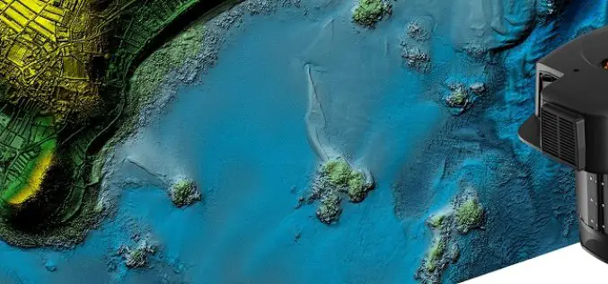
Leica’s New CoastalMapper LiDAR For Airborne Bathymetric Mapping
Leica Geosystems, part of Hexagon, has announced the launch of the Leica CoastalMapper. Thanks to a wider field of view and the ability to be flown at higher altitudes, the
Topcon Announces Landmark Expansion of Topnet Live Network Across USA
Topcon Positioning Systems has announced a significant expansion of its Topnet Live reference station network, introducing 200 new geodetic stations strategically positioned across the United States. This comprehensive network upgrade expands the availability

EagleView Launches New Property Data Ecosystem
EagleView, a leading provider of aerial imagery, announces the launch of its new property data ecosystem. The ecosystem has over 60 petabytes of asset data derived from high-definition aerial imagery.

Pixxel Launches World’s Highest-Resolution Hyperspectral Satellites for Climate Action
Pixxel, a California-based space technology company building the world’s highest-resolution hyperspectral satellite constellation, successfully launched the first three satellites of its Firefly constellation on January 15, 2025. The satellites were
Hexagon to Acquire Septentrio, Revolutionising Positioning in Mission-Critical Navigation and Autonomy Applications
Hexagon has announced an agreement to acquire Septentrio NV, a leading OEM provider of Global Navigation Satellite System (GNSS) technologies, to drive innovation and expand the market reach of Resilient
Introducing Geospatial Cloud Serv: The Comprehensive Geospatial Data Management and Visualization Platform
Tech Maven Geospatial launches GeospatialCloudServ, a revolutionary geospatial data serving and content management platform that transforms how organizations collect, manage, analyze, and visualize spatial data across multiple platforms and devices
