
Business

SuperGIS Manuals Are Now Available Online!
No matter you are a GIS beginner or an old hand; we always have some moments that are uncertain about how to use a particular function, like how to create
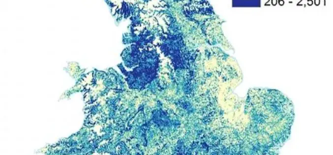
Bluesky Tree Map of Britain Used to Create First High Res Maps of Allergenic Pollen-Producing Plants
A map of over 280 million trees nationwide has been used to create the first high resolution maps of allergenic plants and trees of Great Britain. Detailing the location of
MDA to provide US National Oceanic and Atmospheric Administration (NOAA) with RADARSAT-2 Information for Ice Monitoring
Vancouver, BC – MacDonald, Dettwiler and Associates Ltd. (“MDA” or the “Company”) (TSX: MDA), a global communications and information company, today announced that it has signed a contract with the
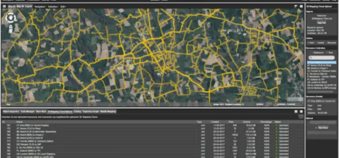
Orbit GT Releases Mobile Mapping Content Manager v17.1 With Cloud Upload Feature
Orbit GT releases v17.1 of its industry-leading Mobile Mapping Content Manager product including the all-new Upload to the Cloud feature. It is available for download today from our website www.orbitgt.com.
Space Flight Laboratory (SFL) Signs Contract with Dubai Space Centre to Build Environmental Monitoring Satellite
TORONTO, Ontario, Canada – 17 May 2017 – The Space Flight Laboratory (SFL) of Toronto announced today the signing of a new contract to provide Dubai-based Mohammed Bin Rashid Space

Icaros Releases Version 5.0 of OneButton™ Drone Image Processing Software
Icaros Releases Version 5.0 of OneButton™ Drone Image Processing Software Free 30-Day Trial FAIRFAX, Virginia, USA, 15 May 2017 – Icaros Inc., a leading provider of aerial imaging software, is pleased
Airbus Creates New Commercial Drone Services Start-up “Airbus Aerial”
– Launches U.S. base and business, headquartered in Atlanta, Georgia – Starts operations with imagery services fusing drones, satellite images, and software to bring deeper insights to commercial customers –

Global Mapper Mobile Now Available for Android Devices
Blue Marble Geographics is pleased to announce the immediate availability of a beta release of the Android version of its Global Mapper Mobile app. Mirroring the capabilities of the iOS

PCI Geomatics Now a Planet Ecosystem Partner
MARKHAM, Ontario, Canada, May 9, 2017 — PCI Geomatics, a world-leading developer of remote sensing and photogrammetric software and systems, announced today it has become a Planet Ecosystem Partner. PCI
World’s Largest Satellite Fleet Owner Joins The Geological Remote Sensing Group
The Geological Remote Sensing Group (GRSG) has expanded its membership once again with the recent news that Planet; the owners and operators of the world’s largest commercially-operated fleet of satellites
