All knew about human intelligence. Recently with the advent of Artificial Intelligence being associated with machine development & deployment, a new concept of location intelligence has evolved.
A location or position has an x, y and/or z coordinate. That’s it. But what is interesting about location (latitude and longitude) is that it is intrinsically linked with all human activity and has gained significance with its association with nearly all aspects of developmental activity.
For long we have qualified location with ‘attributes’ that gave information about specific objects and entities. An attribute gives us a better understating about a location. Say, a position from which the slope of a canal changes or the height on a hill top suitable as a site for a power pylon. More attributes could be attached to a specific location to provide more information for its optimum use.
So what is it that has prompted us to use the term ‘location intelligence’?
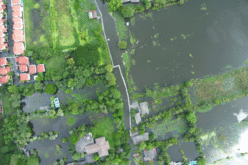
The proliferation of data has made it possible to analyse & understand processes taking place at a location. Rainfall data collected from rain gauges located in a certain region provide a rainfall pattern. Combine this with data from these rain gauges for over a decade and you have a better understanding of the rainfall pattern over a region which planners put to use in optimising agricultural produce or flood mitigation. Heat sinks for urban development, hot spots for crime prevention, estimation of crop failure etc are all aspects of location intelligence being put to use not only for planning & development but also for better and more efficient delivery of services.
Carefully combined with Artificial Intelligence and we have a powerful tool for sustainable development. Interpretation of location intelligent data with suitable boundary conditions can lead to meaningful solutions for the betterment of humankind.
The March 2018 edition of the magazine features multiple articles about the aspects of the implementation of location intelligence using geospatial technologies.