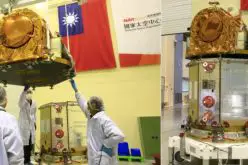
China has successfully launched the Gaofen-12 (05) satellite, adding to its growing Earth observation system, CHEOS. The satellite was carried into orbit aboard a Long March 4C rocket, lifting off from the Jiuquan Satellite Launch Center on October 15, 2024.
This launch marks the fifth addition to the Gaofen-12 series, which contributes to China’s efforts in providing high-resolution, all-weather, and round-the-clock Earth observation capabilities.
The Gaofen-12 satellites are part of the larger CHEOS program, which began with the first Gaofen satellite launch in 2013. The goal of CHEOS is to offer comprehensive remote sensing coverage for both civilian and military applications. While Gaofen-12 is nominally a civilian satellite, its full range of capabilities has not been disclosed, prompting speculation about its potential military use, similar to China’s Yaogan satellites.
Also Read – China Launches Hyperspectral Remote Sensing Satellite – Gaofen-5 02
Comparison with Previous Gaofen Satellites
The Gaofen series includes a variety of satellites, each designed for specific tasks. For example, Gaofen-11, launched in 2018, is known for its high-resolution optical imaging capabilities, reportedly offering imagery with a resolution as sharp as 10 centimeters.
In contrast, earlier Gaofen models like Gaofen-1 focused more on optical imaging with moderate resolution for broader area coverage. The latest Gaofen-12 satellite has not had its exact resolution and technical details released to the public, a trend that began with Gaofen satellites numbered 8 and above.
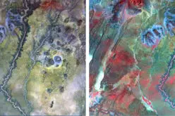
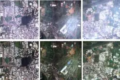
Unlike Gaofen-11, which was specifically designed for high-precision mapping and monitoring, the Gaofen-12 (05) satellite is equipped with a variety of sensors, including synthetic aperture radar (SAR), which allows it to capture detailed images even through cloud cover or at night. This makes Gaofen-12 highly versatile for tasks such as land surveys, disaster relief, and crop yield estimation.
Strategic Significance
The Gaofen-12 (05) satellite is part of China’s broader strategy to enhance its remote sensing capabilities. With the addition of this satellite, China now boasts a more robust network for monitoring land use, urban planning, road networks, and environmental changes. This advanced Earth observation capacity is critical for both civilian and military purposes, especially considering the gaps in publicly available data for Gaofen-12 and later versions.
In comparison to other Earth observation satellites launched in recent years, Gaofen-12 brings an additional layer of precision and reliability. While its exact specifications are under wraps, it is clear that China is using the Gaofen satellites to strengthen its national defense and environmental monitoring systems.
With Gaofen-12 now in orbit, China continues to advance its leadership in Earth observation technology. As more satellites join the CHEOS system, the nation will enhance its ability to monitor and respond to a variety of challenges, from natural disasters to urban development. As the space race intensifies, Gaofen-12 serves as another example of China’s growing dominance in satellite technology, setting the stage for future innovations.
Source: Ecns.cn