How Geospatial Mapping in Agriculture is Revolutionizing Crop Management Across South Asia By ICRISAT
A recent study by scientists from the International Crops Research Institute for the Semi-Arid Tropics (ICRISAT) has brought to light the pivotal role of geospatial mapping and satellite data in transforming agricultural practices across South Asia.
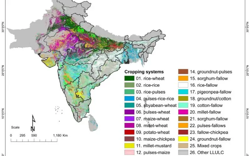
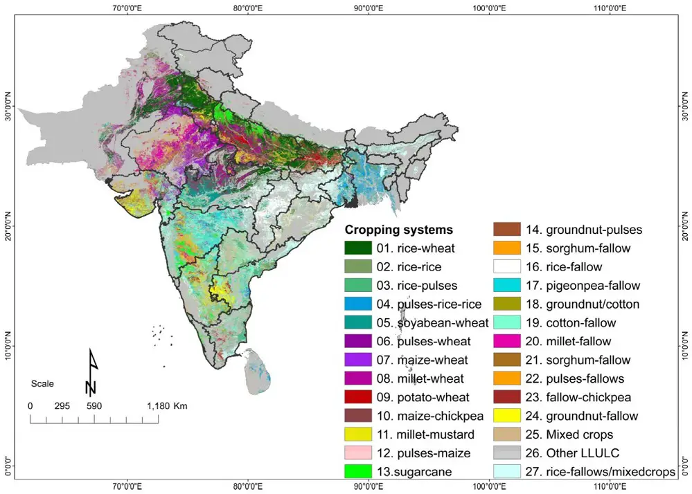
Spanning a vast region of 477 million hectares across India, Pakistan, Nepal, Bhutan, Bangladesh, and Sri Lanka, the study identified 27 major cropping systems, highlighting the potential of advanced tools in boosting agricultural productivity and ensuring food security in the region.
Addressing the Urgency for Sustainable Agriculture
With only six harvest seasons remaining before the 2030 Sustainable Development Goals (SDGs) deadline, the need to increase agricultural productivity sustainably has become urgent. South Asia’s drylands, in particular, present significant opportunities for growth. By utilizing geospatial tools, policymakers and agricultural experts can develop strategies to optimize resource use and make more informed decisions about crop management.
Unlike traditional studies that focus on individual crops, such as wheat or rice, this research adopts a broader approach by mapping entire cropping systems. These systems reflect the sequence of crops grown throughout the year, providing a comprehensive understanding of regional agricultural patterns. This holistic approach offers a clearer view of how crops interact with environmental factors and helps create strategies that ensure sustainable intensification of agricultural production.
Leveraging Geospatial Data for Policy and Disaster Management
One of the key advantages of geospatial mapping is its ability to inform policies that ensure efficient resource distribution. The data allows governments to optimize the use of water, fertilizer, and seeds based on the specific needs of different cropping systems. This precision enables farmers to achieve higher yields while minimizing waste, making agriculture more sustainable.
Also Read – Geospatial Technologies for Crop Damage and Compensation Estimation
Moreover, these maps can be integrated into disaster management strategies. By identifying areas at risk of agricultural stress due to natural calamities like droughts or floods, governments can take targeted actions to protect vulnerable regions. Such proactive measures help mitigate the damage to crops, ensuring that food production remains stable even in challenging conditions.
A Global Perspective on Climate Change
Beyond national benefits, geospatial maps contribute to global efforts in combating climate change. By providing essential data on land use and crop performance, these tools help scientists and policymakers understand the impact of climate shifts on agriculture. This information is invaluable for developing strategies to enhance resilience and adaptability in farming practices, ultimately securing food supplies for future generations.
Funding and Global Collaboration
The study, titled Spatial Distribution of Cropping Systems in South Asia Using Time-Series Satellite Data Enriched with Ground Data, received financial backing from multiple global organizations. Funding sources included the Japan Fund for Prosperous and Resilient Asia and the Pacific, supported by the Government of Japan through the Asian Development Bank (ADB). The research also received support from the Mahalanobis National Crop Forecasting Centre (MNCFC) of India’s Ministry of Agriculture and Farmers Welfare, the WRI Land & Carbon Lab grant convened by the World Resources Institute, and the Bezos Earth Fund.
Conclusion
This landmark research underscores the transformative power of geospatial mapping and satellite data in driving agricultural productivity across South Asia. By combining these tools with climate and soil data, the study offers a promising pathway for enhancing food security and achieving the SDGs. The insights gained from this study hold the potential to shape agricultural policies and practices not only in South Asia but around the world.