3D Mapping
Credit: Daily Mail
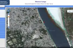
Indian national Centre for Ocean Information Services (INCOIS) has started survey of cyclone prone areas. The survey carried out to build a comprehensive database of all residential and other construction along the coastal area in and Machilipatnam.
The survey, a pilot project being carried out in Tamil Nadu and Machilipatnam in Andhra Pradesh, was meant to develop a 3D mapping of the respective locations as these were observed most cyclone prone areas in South India.
“The survey collects location, period of construction of a building and other population data in and around Machilipatnam in Andhra Pradesh. This is an exercise by the INCOIS to prepare an action plan for preparation of any disaster in coming years”, INCOIS Survey In-Charge S. Yamini Kumar told The Hindu.
Other locations along the coastline of the country would be covered in the survey in the next phase based on the results of the present survey, he added.
“The preparation of 3D mapping of the respective areas will solely based on the existing geographical locations of the buildings, covered under the survey which began in mid September”, said Mr. Kumar.
INCOIS is mandated to provide the best possible ocean information and advisory services to society, industry, government agencies and the scientific community through sustained ocean observations and constant improvements through systematic and focussed research.
Source: The Hindu