L-Band SAR Backscatter Related to Forest Cover, Height and Aboveground Biomass at Multiple Spatial Scales across Denmark

L-Band SAR Backscatter Related to Forest Cover, Height and Aboveground Biomass at Multiple Spatial Scales across Denmark
– Neha P. Joshi, Edward T. A. Mitchard, Johannes Schumacher, Vivian K. Johannsen, Sassan Saatchi and Rasmus Fensholt
Abstract: Mapping forest aboveground biomass (AGB) using satellite data is an important task, particularly for reporting of carbon stocks and changes under climate change legislation. It is known that AGB can be mapped using synthetic aperture radar (SAR), but relationships between AGB and radar backscatter may be confounded by variations in biophysical forest structure (density, height or cover fraction) and differences in the resolution of satellite and ground data.
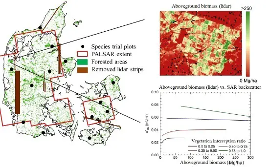 Here, we attempt to quantify the effect of these factors by relating L-band ALOS PALSAR HV backscatter and unique country-wide LiDAR-derived maps of vegetation penetrability, height and AGB over Denmark at different spatial scales (50 m to 500 m). Trends in the relations indicate that, first, AGB retrieval accuracy from SAR improves most in mapping at 100-m scale instead of 50 m, and improvements are negligible beyond 250 m. Relative errors (bias and root mean squared error) decrease particularly for high AGB values ([Math Processing Error]110 Mg ha[Math Processing Error]) at coarse scales, and hence, coarse-scale mapping ([Math Processing Error]150 m) may be most suited for areas with high AGB. Second, SAR backscatter and a LiDAR-derived measure of fractional forest cover were found to have a strong linear relation (R[Math Processing Error] = 0.79 at 250-m scale). In areas of high fractional forest cover, there is a slight decline in backscatter as AGB increases, indicating signal attenuation. The two results demonstrate that accounting for spatial scale and variations in forest structure, such as cover fraction, will greatly benefit establishing adequate plot-sizes for SAR calibration and the accuracy of derived AGB maps.
Keywords: ALOS PALSAR; airborne LiDAR; canopy density; aboveground biomass; mapping scale; non-linear modeling;vegetation interception ratio
Download Full Paper