Mapping Oil Palm Plantations in Cameroon Using PALSAR 50-m Orthorectified Mosaic Images
Mapping Oil Palm Plantations in Cameroon Using PALSAR 50-m Orthorectified Mosaic Images
-By: Li Li, Jinwei Dong, Simon Njeudeng Tenku and Xiangming Xiao
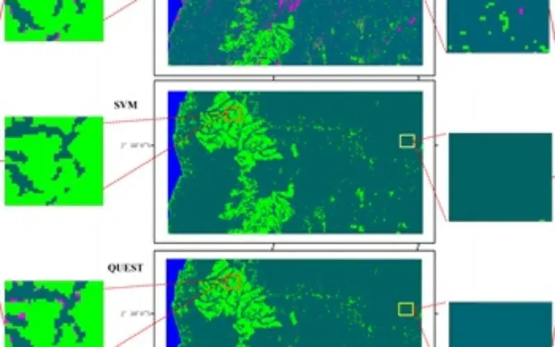
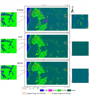 Abstract: Oil palm plantations have expanded rapidly. Estimating either positive effects on the economy, or negative effects on the environment, requires accurate maps. In this paper, three classification algorithms (Support Vector Machine (SVM), Decision Tree and K-Means) were explored to map oil palm plantations in Cameroon, using PALSAR 50 m Orthorectified Mosaic images and differently sized training samples. SVM had the ideal performance with overall accuracy ranging from 86% to 92% and a Kappa coefficient from 0.76 to 0.85, depending upon the training sample size (ranging from 20 to 500 pixels per class). The advantage of SVM was more obvious when the training sample size was smaller. K-Means required the user’s intervention, and thus, the accuracy depended on the level of his/her expertise and experience. For large-scale mapping of oil palm plantations, the Decision Tree algorithm outperformed both SVM and K-Means in terms of speed and performance. In addition, the decision threshold values of Decision Tree for a large training sample size agrees with the results from previous studies, which implies the possible universality of the decision threshold. If it can be verified, the Decision Tree algorithm will be an easy and robust methodology for mapping oil palm plantations.
Keywords: unsupervised classification; K-Means; support vector machine; decision tree; PALSAR; oil palm