
Archive
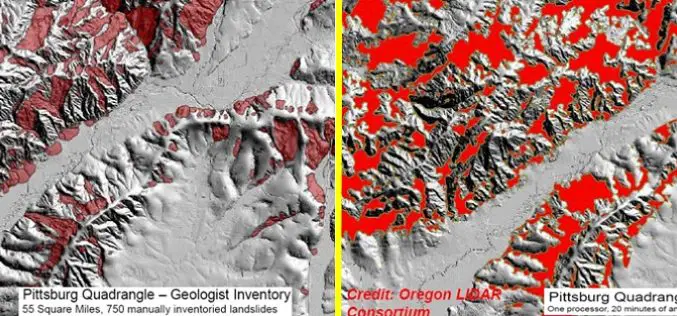
Contour Connection Method: an automated Method for Landslide Identification with LiDAR
In a study by Ben A. Leshchinsky et. al., from Oregon State University has developed a new algorithm “Contour Connection Method” for automated landslide deposits from LiDAR data. Landslide is

New Mapping Agreement to Benefit United Kingdom and Ireland Location Data Users
A new three party agreement between Ordnance Survey (GB), Ordnance Survey Ireland (OSi) and Land and Property Services (LPS) Northern Ireland is set to improve access and availability of mapping services for

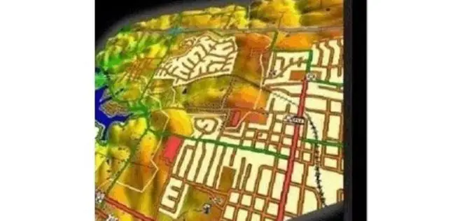
Esri India Webinar: Modeling Smart Cities with Esri CityEngine & ArcGIS
Building a sustainable future city is a complex process and a significant challenge for urban planners and designers. Hence, planning has a critical role in any Smart City design helping
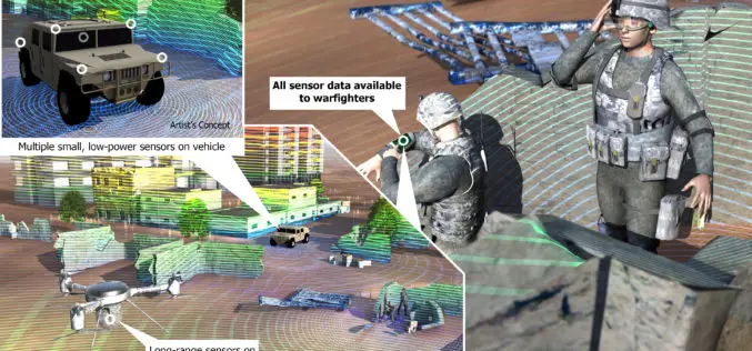
DARPA Develop Technology to Integrate LiDAR on Microchips
DARPA, American defence research agency has developed a LiDAR system small enough to be integrated on a microchip yet offering better performance than conventional bulky mechanical devices. DARPA’s Short-range Wide-field-of-view Extremely agile

Postdoctoral Opportunity in Earth and Environmental Science, Temple University
The Department of Earth and Environmental Science offers students the opportunity to study the Earth with a variety of traditional and environmental geology course work. The faculty work closely with

Saab and DigitalGlobe Announce Vricon Joint Venture to Create the Globe in 3D
Vricon will create high resolution elevation products and accurate, immersive 3D products with unmatched coverage and delivery timelines Defense and security company Saab and DigitalGlobe, Inc. (NYSE:DGI), a leading global
Updated Global Mapper LiDAR Module Now Supports NIR LiDAR Data
Hallowell, Maine – May 27, 2015 – Blue Marble Geographics (bluemarblegeo.com) is pleased to announce the availability of an upgrade to the Global Mapper LiDAR Module. Released in conjunction with
SPOT-Based Sub-Field Level Monitoring of Vegetation Cover Dynamics: A Case of Irrigated Croplands
SPOT-Based Sub-Field Level Monitoring of Vegetation Cover Dynamics: A Case of Irrigated Croplands – Olena Dubovyk, Gunter Menz, Alexander Lee, Juergen Schellberg, Frank Thonfeld and Asia Khamzina Abstract: Acquiring multi-temporal spatial information on vegetation condition

Attend Talk on From SAR to Spatial Data Infrastructures – Applied Remote Sensing
Talk: From SAR to spatial data infrastructures – Applied remote sensing at the Chair of Remote Sensing at the Friedrich-Schiller-University Jena – by Carsten Pathe, Jonas Eberle The talk will give
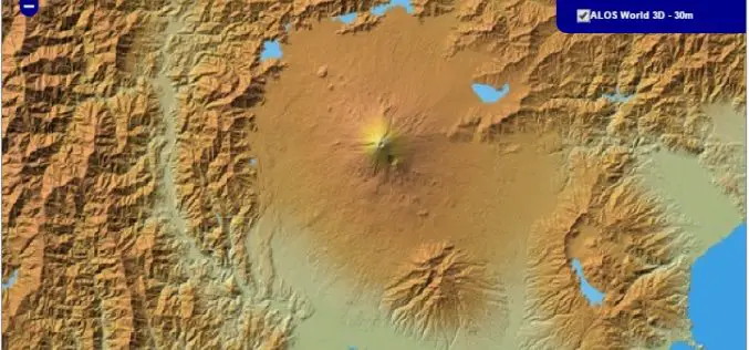
30 meter World Elevation Data is Now Available at JAXA’s Site Free of Charge!
The Japan Aerospace Exploration Agency (JAXA) will begin publishing free of charge an elevation data set that can express undulations of terrain over the world with a resolution of 30
