The need for a receiver-independent exchange format (RINEX) emerged during the planning of the first large European GPS campaign, EUREF 89. This campaign involved over 60 GPS receivers from four different manufacturers, each using their proprietary output file formats for the GPS data they collected. For instance, Trimble’s GPS data output formats include .DAT, T01, and T02 extensions.
The Development of RINEX
To address the challenge of exchanging GPS data among various receivers, the Astronomical Institute of the University of Berne in Switzerland proposed the RINEX format. RINEX, or Receiver Independent Exchange Format, standardizes the GPS data format, making it universally acceptable and easy to exchange regardless of the receiver’s make or model.
Understanding
GPS Signals
To appreciate the significance of RINEX, it’s helpful to understand the basics of GPS signals. A GPS signal consists of two carrier waves, L1 and L2, each modulated with specific codes and a navigation message:
L1 Frequency:
Frequency: 1575.42 MHz
Wavelength: 19 cm
Modulation: C/A code, P or Y code, and navigation message
The proprietary formats of different manufacturers can make data integration and analysis cumbersome. By providing a universal format, RINEX ensures that GPS data from different sources can be easily shared, analyzed, and interpreted. This standardization is crucial for large-scale GPS campaigns and various applications requiring precise and consistent GPS data.
What is a RINEX File
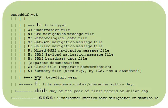
RINEX file is an ASCII file format. The file structure of a RINEX file is as follows:
Example: 04843350.13o(Observation file) and 04843350.13n(Navigation file)
Advertisements
0484 : Station name or id
335: Julian day or day of the year of first record (Date: 01 Dec 2013)
0: File sequence (Here it is first file of the day)
13: Two digit of year (2013)
o: Type of file (Observation file)
n: Type of file (Navigation file)
Up till now [2014], 3 major RINEX format versions have been developed:
RINEX version1 – presented and accepted by the 5th International Geodetic Symposium on Satellite Positioning in Las Cruces, 1989.
RINEX version 2 – presented and accepted by the 2nd International Symposium of Precise Positioning with the Global Positioning System in Ottawa, 1990.
RINEX Version 3 – The new version also includes the unofficial Version 2.20 definitions for space-borne receivers.
The RINEX version 3.00 format consists of three ASCII file types:
Observation Data File : C/A code, P or Y code, L1 and L2 or Time, Phase, and Range
Navigation Message File : epoch, satellite clock information
Meteorological Data File : Pressure (mbar), Dry temperature (deg Celsius), Relative Humidity , Wet zenith path delay (millimeters)(percent)
Each file type consists of a header section and a data section. The header section contains global information for the entire file and is placed at the beginning of the file. The header section contains header labels in columns 61-80 for each line contained in the header section.
Each Observation file and each Meteorological Data file basically contain the data from one site and one session. Starting with Version 2 RINEX also allows to include observation data from more than one site subsequently occupied by a roving receiver in rapid static or kinematic applications. Although Version 2 and higher allow to insert header records into the data field it is not recommended to concatenate data of more than one receiver (or antenna) into the same file, even if the data do not overlap in time. The format of the data records of the RINEX Version 1 navigation message file was identical to the former NGS exchange format. RINEX version 3 navigation message files may contain navigation messages of more than one satellite system (GPS, GLONASS, Galileo, SBAS). (Source: Astronomical Institute University of Bern)
Meteorological Data File – Header Section Description
Meteorological Data File – Data Record Description
You may also download a RINEX file to get a real-time understanding about the Rinex file format, follow the link to download RINEX file: http://goo.gl/l3xIk9
GIS Resources is an initiative of Spatial Media and Services Enterprises with the purpose that everyone can enrich their knowledge and develop competitiveness.
GIS Resources is a global platform, for latest and high-quality information source for the geospatial industry, brings you the latest insights into the developments in geospatial science and technology.