
Introduction
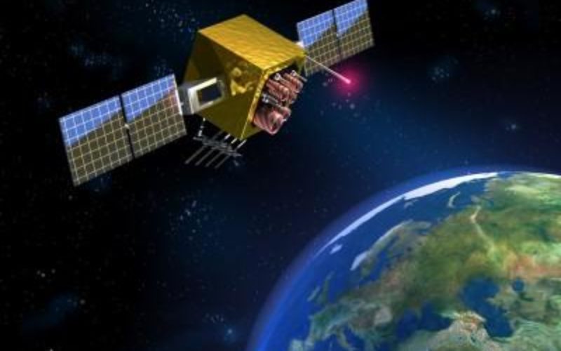
The Global Positioning System (GPS) is a U.S. military-run navigation system that operates on three L-band frequencies (a portion of the radio spectrum between 1 and 2 GHz.): L1, L2, and L5. The first GPS satellite was launched in 1978, and the network has since expanded to include more than 24 satellites.
Now GPS is everywhere, we use it to get around in our cars, track our workouts, and even find the closest coffee shop. GPS signals are transmitted by satellites in space and received by receivers on Earth. There are three civilian GPS frequency bands: L1, L2, and L5. In this post, we’ll take a closer at the GPS L1, L2, and L5 frequencies and what they mean or what signal message they carry from GPS satellites to GPS receivers.
What
are the GPS L1, L2, and L5 Frequencies?
Global Positioning System (GPS) satellites circle the Earth twice a day in very precise orbits. They continuously transmit signals that allow GPS receivers on the ground to calculate their location, speed, and direction.
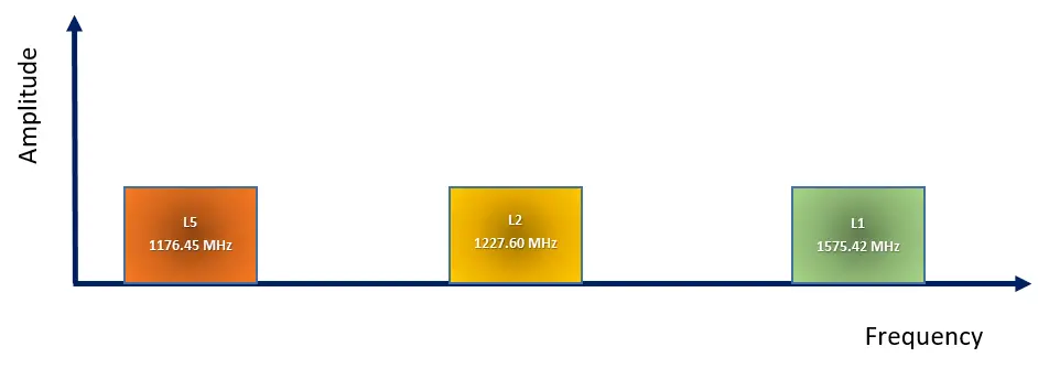
GPS first began operations with two signals, L1 and L2. L1 operates at a frequency of 1575.42 MHz, whereas L2 operates at a frequency of 1227.60 MHz. These GPS signals include two ranging codes: P (Y) or Precision code and C/A (Carrier Acquisition) code. The first code is only for military use, while the second is only for civilian use. These range codes are used to calculate the distance to the satellite as well as to identify the navigation message uniquely.
Although the GPS system has nearly reached its full operational capabilities, modernization and implementation of a new GPS system have recently begun due to increased demand for better service and technological improvements. The insertion of L5 GPS signals is part of the US Department of Defense’s modernization activities.
Now there are three civilian GPS frequencies: L1 at 1575.42 MHz, L2 at 1227.60 MHz, and L5 at 1176.45 MHz. Each frequency has unique properties that make it better suited for certain types of applications. For example, L1 frequency is used to track GPS satellite location, L2 frequency is used to track the health of the GPS satellites and the L5 frequency is used to improve accuracy for civilian use such as aircraft precision approach guidance.
Let’s look into details about GPS L1, L2, and L5 Frequencies-
GPS L1 Frequency
L1 sends a navigation message at 1575.42 MHz, the coarse acquisition C/A code (which is open to the public), and an encrypted precision (P) code known as the P(Y) code (restricted access). The navigation message is a low-bit-rate communication that contains the following data:
- GPS time and date.
- The status and health of the satellite. If the satellite is experiencing problems or its orbit is being changed, it will be rendered inoperable. When this occurs, the satellite will send an out-of-service message.
- Satellite ephemeris data, which allows the receiver to compute the position of the satellite. This information is correct in many decimal places. Receivers can pinpoint the exact location of the satellite at the time it transmitted its time.
- The GPS Almanac contains information and status for all GPS satellites, allowing receivers to determine which satellites are accessible for tracking. This “almanac” will be recovered by a receiver upon startup. The almanac consists of coarse orbit details and status information for each satellite in the GPS constellation, an ionospheric model, and information to relate GPS-derived time to Coordinated Universal Time (UTC).
The P(Y) code is only used in the military. It rejects interference better than the C/A code, making military GPS more robust than civilian GPS.
GPS L2 Frequency
The L2 operates at 1227.60 MHz, which has a lower frequency than the L1. This permits the signal to pass through obstacles such as cloud cover, trees, and buildings more effectively. The L2 frequency transmits the P(Y) code and, on newer GPS satellites, the C/A code (referred to as L2C), providing civilian users with a second publicly available code.
Also, read – What is Virtual Reference Station?
GPS L5 Frequency
The L5 operates at 1176.45 MHz, with higher transmission power and enhanced signal architecture compared to other GPS signals (L1 or L2), it is expected that L5 will improve the GPS system’s current performance. The L5 signal is projected to provide a high processing gain due to its large bandwidth and relatively longer spreading codes.
One of the distinguishing characteristics of the L5 signal is the inclusion of both a distinct carrier and a quadrature data modulation component. On L5, two pseudo-noise codes (also known as a pseudorandom binary sequence) (PN or PRN code) ranging codes are transmitted: the in-phase code (also known as the I5-code) and the quadrature-phase code (denoted as the Q5-code).
It will be employed in life-saving transportation as well as other demanding applications such as aviation. It will eventually become another civilian-accessible signal. Because it is so new, it isn’t yet useful for surveyors, but it is something to take in mind when developing future GPS receivers.
How is the GPS signal transmitted?
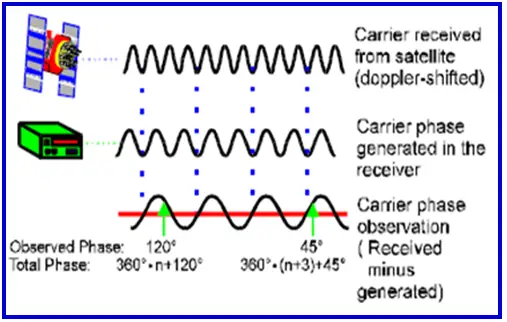
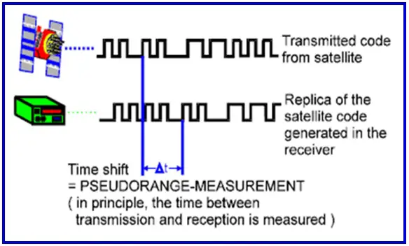
GPS uses a transmission scheme which is called CDMA, i.e Code Division Multiple Access.
Although GPS satellite signals use the same frequency, they are modulated by a distinct pseudorandom digital sequence or code. Each satellite has a unique pseudorandom code. Pseudorandom means that the signal merely appears random; in reality, it repeats after a certain amount of time. Each satellite’s pseudorandom code is known to receivers. This enables receivers to correlate (synchronize) with a specific satellite’s CDMA signal. The CDMA signals are at a very low level, yet the receiver is able to retrieve the signals and the information they convey thanks to code correlation.
Also, read – How Virtual Reference Station (VRS) Work?
What are the benefits of using the different GPS frequencies (L1, L2, and L5)?
If we understand the behavior of microwaves frequencies in terms of signal processing, transmission and reception, antennas, bandwidth, travel distance, reflectance, and the impact of the earth’s atmosphere (particularly the ionosphere), we can easily find the reason for three different GPS frequencies.
The advantages that can be enumerated based on the aforesaid elements and their impact on microwave/GPS signals are as follows.
- Antenna design simplification. If the frequency had been substantially higher, the user antennas might have been required to be a little more complicated.
- At lower frequencies, the ionospheric delay is more pronounced.
- The coding system necessitates a large bandwidth, which is not available in all frequency bands.
- The frequency range was chosen to minimize the effect of weather on GPS signal propagation.
Combining two frequencies while GPS observation and reducing error. Since L2 signal has a lower frequency and thus a higher wavelength, it can travel much more easily through obstacles. This means that errors caused by particles in the air can be calculated and eliminated by comparing the two signals. This gives a higher level of accuracy comparable to when using the L1 frequency, which gives accuracy in meters.
What is the future of GPS technology?
The future of GPS technology looks bright. New applications are being developed that will take advantage of the superior capabilities of GPS frequency technology. These new applications include smart cities, autonomous vehicles, and intelligent transportation systems.
GPS technology is also being used in new and innovative ways to improve the accuracy of location tracking. This is making it possible to track objects and people with a much greater degree of precision. This is having a major impact on a wide range of industries – most notable in commercial vehicle tracking (examples of these devices here), as well as in logistics, shipping, and manufacturing.
Together with other positioning and location technologies, such as Galileo, GLONASS, BeiDou, and IRNSS, GPS can play a very important role. The collective term for all these technologies is known as Global Navigation Satellite System (GNSS). These technologies are becoming more and more accurate, and they are being built into more and more devices.
GPS is also being threatened by the development of 5G. 5G will provide much faster data speeds and lower latency than GPS. This could make it a more attractive option for location-based services.
Conclusion
GPS L1, L2, and L5 frequencies are important to understand if you want to do precise navigation, positioning, surveying, and various other PNT (Positioning, Navigation, and Timing) applications. These three frequencies work together to provide accurate location data. If you’re curious to learn more, about “GPS Field Observation and Data Processing” and “GPS Surveying Techniques” refer to the following links-
References- Hindawi, Geoconnect, NovAtel


Hello, I am confused by the statement: “The L2 operates at 1227.60 MHz, which is faster than the L1. ” Do these signals not all travel at the constant speed of light? I thought neither could be faster. There could certainly be a higher frequency.
Hi, you pointed out it correctly. Thanks for bringing this to our notice the text has been updated to “lower frequency”.
L2 is not higher in frequency than L1, but it has a larger wavelength, which allows it to pass through obstacles somewhat better. Please correct the text where this was written (more than once).
Thanks for bringing out the discrepancies. The text has been updated correctly.
They have been sending CNAV on L5 since 2014, what is stopping L5 from becoming active?
I am not sure what you mean by active here. I checked and received L5 signal from GPS satellites. If you are not receiving L5 check your receiver whether its supports L5 or not. Attached is image showing L1,L2 and L5 received by a receiver – https://gisresources.com/wp-content/uploads/2023/01/L1-L2-L5-frequencies.jpeg
OP probably meant “operational”. According to gps.gov on 9/4/2023 at https://www.gps.gov/systems/gps/modernization/cnav/ “The L2C and L5 signals are currently PRE-OPERATIONAL and should NOT be used for safety-of-life or other critical purposes until the government declares them operational.” “Operational declarations for L2C and L5 will require implementation of new monitoring and control capabilities in Block 1 of the Next Generation Operational Control System (OCX).” Also of interest, on Aug. 8, 2023 Defense One said that “Raytheon Technologies’ long-troubled ground stations that will control the Pentagon’s constellation of GPS satellites won’t be ready till next year—seven years behind schedule.” https://www.defenseone.com/technology/2023/08/long-overdue-gps-ground-stations-delayed-pandemic-chinese-hardware/389220/ GPS World explained on August 24th that a delay incurred by the pandemic, then another delay when IBM sold their server division to a Chinese company, and their contract was modified as a result. https://www.gpsworld.com/gps-ocx-still-delayed-and-lawmakers-are-not-happy/
When you say “GPS first began operations with two signals, L1 and L2. L1 operates at a frequency of 1575.42 MHz, whereas L2 operates at a frequency of 1227.60 MHz. These GPS signals include two ranging codes: P (Y) or Precision code and C/A (Carrier Acquisition) code. The first code is only for civilian usage, while the second is only for military use. These ranges codes are used to calculate the distance to the satellite as well as to uniquely identify the navigation message.”, I believe that you meant the opposite. The first code is only for military use and the second is for civilian use per the rest of the article.
Howdy, thank you pointing the mistake. We have correct the statement.