Singapore Land Authority 3D Smart Nation Map Debuts on the World Stage
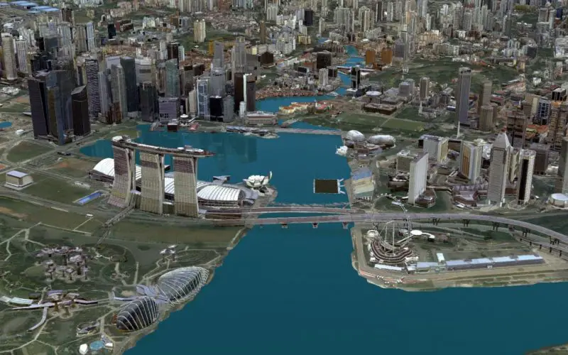
The Singapore Land Authority (SLA) has revealed the highly anticipated first phase of its national 3D mapping project to an audience of more than 16,500 of the world’s leading geospatial professionals – at the Esri International User Conference (UC) in San Diego this week.
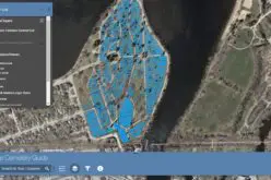
The 3D models being showcased at the event – which use advanced Geographic Information System (GIS) technology to generate compelling ‘real world’ visualisations of the entire island – are part of a whole-of-government Smart Nation initiative aimed at improving risk management, facilitating collaboration and enhancing decision-making among Singapore’s public agencies.
Singapore Land Authority 3D Smart Nation Map; Credit: Esri Singapore
The project has also produced the biggest geospatial dataset ever collected homogenously in Singapore, featuring more than 100 terabytes of data and products which can be used by multiple agencies to create 3D maps and models.
SLA CE Tan Boon Khai said “SLA is committed to pushing geospatial and technological boundaries to propel Singapore towards a Smart Nation. We are leading the development of Singapore’s 3D mapping initiative which would form a key component of Virtual Singapore. This would enable sharing and analysis of geospatial data to improve sense-making capabilities, test-bedding and assimilation of concepts to find solutions to emerging and complex challenges.”
Esri Singapore CEO Thomas Pramotedham – who is in San Diego to support SLA’s week-long showcase entitled “3D mapping of Smart Singapore” – said the project would serve as a new global benchmark for the world’s leading cities.
“Singapore is one of the most advanced in the world when it comes to using GIS technology for Smart Nation development,” Mr Pramotedham said.
“Traditional 2D town planning maps are inadequate to represent our complex environment, but when city planning scenarios are translated into a 3D ‘real world’ scenario, we can design, build and develop with absolute clarity and precision.
“By using GIS technology, SLA has been able to truly bring their vast array of data alive in a way not possible with any other tool. As a result, government agencies are now positioned to make smarter decisions regarding the future of Singapore.”
“For example, the 3D models could be used to identify the island’s solar energy potential; determine how proposed new buildings may affect the city’s skyline; and subterranean planning with the optimisation of underground land use.”
SLA’s 3D models – which are on display at the Esri UC National Government Exhibit until Friday – will form a key component of Virtual Singapore, one of the projects under the Smart Nation initiative.
Other examples of how SLA’s 3D models may be used include:
- Analysing how the location of where trees are planted may increase a park’s shade coverage during the day, thereby increasing citizens’ comfort levels and patronage of parks. This type of ‘dynamic shadow analysis’ can also help Singapore’s planners better locate new park benches, rest points and activity areas for the greater comfort of park goers.
- Enabling property developers to understand how Singapore’s weather patterns and an area’s existing greenery could assist in naturally cooling-down a built-up environment. This will help cut down energy usage in buildings, especially from cooling load demands.
- Providing urban planners with greater insight into how new building developments can change or obstruct the visibility of certain landmarks, tourist attractions, or community facilities. As an example, this can help organisers at the Arts and Science Museum determine the best spots for viewing the light show, thereby helping ensure a unique and great experience for every visitor.
- Effectively using and managing Singapore’s underground space to host future developments such as malls and MRT stations.
- Enabling government agencies to seamlessly share data in real-time in areas such as routing, navigation and field operations. This can be especially helpful when organising large-scale public events such as the 2016 Formula 1 race – an event that requires meticulous route planning and real-time data knowledge to ensure the smooth flow of the event.
- Undertaking solar energy forecasts to identify suitable areas for solar panel installation. By conducting a solar potential analysis, the utilities industry can fully leverage Singapore’s solar power potential thereby providing consumers with a reliable source of renewable energy.
For further information on how GIS technology is enabling Singapore’s Smart Nation initiative – contact Esri Singapore on 6742 8622.