
Tag "GPS Aided Geo Augmented Navigation"
GIS
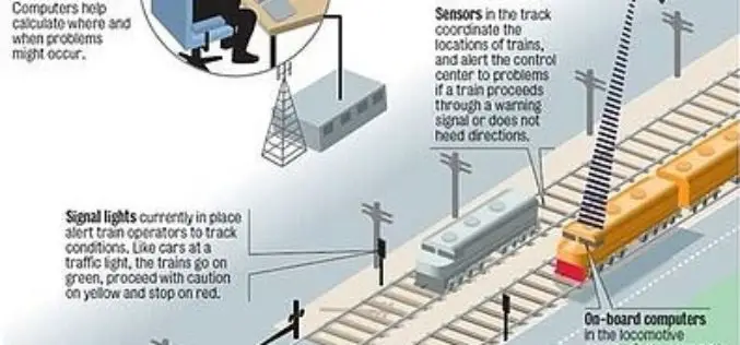
Indian Railways to Tie Up With ISRO for Enhanced Safety Using GPS Aided System (GAGAN)
Indian Railways will join hands with ISRO to get online satellite images for improving safety and enhancing efficiency. “We will undertake a massive exercise of GIS mapping of the entire

Global Positioning System
GAGAN Will Become Fully Operational in February
In recent news, GAGAN-GPS Aided Geo Augmented Navigation System will become fully operational in month of February this year as conformed by S. V. Satish, GM-Air Traffic Management, Gagan project, Airports
Global Positioning System
GAGAN System Certified for RNP0.1 Operations
The Directorate General of Civil Aviation (DGCA), India has provisionally certified the ambitious Satellite Based Augmentation System (SBAS) programme of India – GPS Aided Geo Augmented Navigation (GAGAN) system
