A £1M research initiative, SUPERSLUG, is set to address landslide risks in the Himalayas, using advanced remote sensing and geo-technology to mitigate the long-term impacts of sediment movement on landscapes and communities.
Landslides, avalanches, and glacial floods can devastate areas in their immediate path, but their effects often extend hundreds of kilometres downstream, impacting river systems and infrastructure years after the event. This project, backed by the Natural Environment Research Council, focuses on understanding these extended risks.
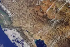
Centered on a 150 km stretch of the Ganges River impacted by the 2021 Chamoli disaster, the SUPERSLUG initiative will use a variety of remote sensing technologies, including drones and satellite imagery, to monitor ongoing changes in the landscape.
Also Read – LiDAR Survey for Landslide Risk Management in Uttarakhand
The Chamoli disaster, triggered by a rock and ice avalanche, resulted in a devastating debris flood that killed over 200 people and caused severe damage to hydropower and transport systems. Despite the initial destruction, the long-term movement of sediment continues to pose significant risks to the region.
The project will leverage seismic sensors, “smart cobbles,” and other geo-technologies to measure sediment transport during both normal and flood conditions. These innovative monitoring methods will provide real-time data to develop numerical models predicting the future impact of such events.
Researchers from leading institutions such as the University of Plymouth and the University of Hull are collaborating with Indian institutions like the Indian Institute of Technology Roorkee to enhance the accuracy of these predictions.
Also Read – IIT Delhi Develops Tool for Automated Mapping of Landslide Events
SUPERSLUG aims to build a digital twin of the river system, providing decision-makers with a robust tool for disaster management and infrastructure planning. Engaging with local communities and authorities, the research will also ensure that findings are practical and actionable for hydropower operators and disaster management professionals.
As global climate change intensifies natural hazards in mountainous regions, the £1M project marks a significant step forward in using remote sensing to safeguard vulnerable communities.
To find out more about the SUPERSLUG project, visit the case study page.