Join the Challenge: Innovators Needed for Space-Based Algal Bloom Monitoring
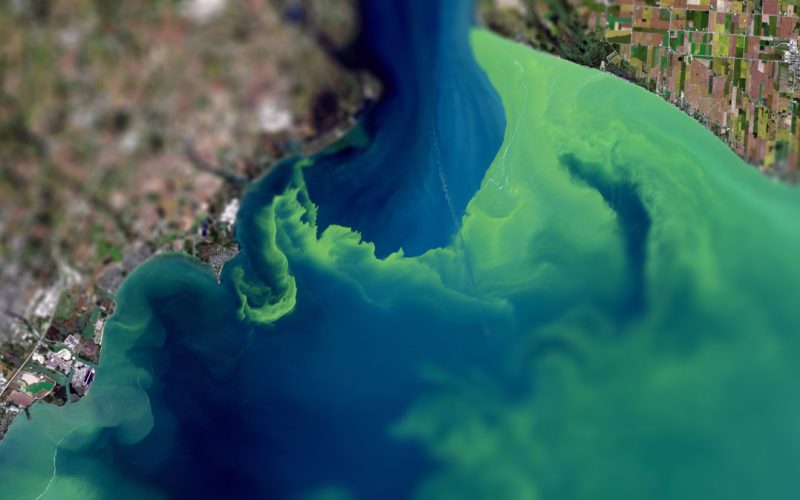
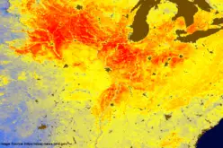
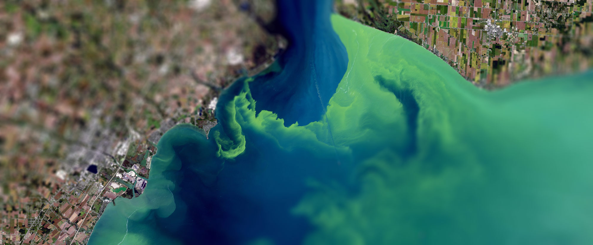
Northern Ireland’s waterways, particularly Lough Neagh, are under increasing threat from severe seasonal blue-green algal blooms. These blooms, driven by pollution, climate change, and invasive species, have significant ecological and economic impacts.
Now, the UK Space Agency (UKSA), in collaboration with NI Space and the Department of Agriculture, Environment and Rural Affairs (DAERA), is inviting organisations to participate in developing innovative solutions to predict, detect, and monitor these harmful algal blooms using space-based technology.
Why Are Algal Blooms a Problem?
Blue-green algae, which thrive due to excess phosphorus and nitrogen in water, as well as warmer water temperatures, can have devastating effects on ecosystems and human health. Lough Neagh, for example, has been experiencing these harmful blooms, which degrade water quality and impact agriculture, fisheries, and tourism.
The Lough Neagh report, published in July 2024, identified key factors driving these blooms, including agricultural runoff, wastewater pollution, and rising temperatures due to climate change. Invasive zebra mussels have also contributed to clearer water, which fosters algae growth.
To tackle this crisis, long-term strategies to reduce nutrient input are essential. However, immediate monitoring and prediction methods are urgently needed to control the blooms and mitigate their impact.
The Challenge: Space-Based Solutions for Algal Bloom Monitoring
To address this pressing issue, UKSA is looking for innovators capable of leveraging remote sensing technologies to provide a solution for monitoring and predicting algal blooms in Lough Neagh and other affected water bodies across Northern Ireland. These solutions should combine satellite data with terrestrial technologies such as AI, machine learning, drones, and geospatial data to deliver comprehensive insights.
The aim is to develop real-time, scalable monitoring tools that can help authorities predict algal bloom formation, monitor their spread, and manage their impact. While Lough Neagh is the primary focus, the proposed solutions should demonstrate the potential for use in other UK waterways as well.
Also Read – Remotely Sensing the Complexity of Rivers and Estuaries
Get Involved: Funding and Opportunity
This call for proposals is part of the Unlocking Space for Government (USG) programme, with a budget of £360,000 allocated for Phase 1. Three successful bidders will receive funding of up to £120,000 each, depending on their proposals. Phase 1 will run until March 2025, with the possibility of moving into Phase 2 in the 2025-2026 financial year.
Why Participate?
- Gain funding to develop cutting-edge remote sensing solutions.
- Collaborate with leading organisations in space technology and environmental protection.
- Contribute to a critical environmental challenge that has far-reaching impacts across the UK and beyond.
- Have the opportunity to see your solution implemented to make a real difference in water management and public health.
Who Can Apply?
The SBRI competition is open to eligible organisations across the UK, EU, and European Economic Area. Organisations can apply as standalone entities or as part of a team with subcontractors. The competition welcomes proposals from companies with expertise in AI, quantum technology, machine learning, geospatial data, and satellite services.
If your organisation is interested in developing a solution that uses space-based technology to predict and monitor blue-green algal blooms, now is the time to get involved!
Apply Today
Don’t miss your chance to be part of this groundbreaking initiative. By participating, you will not only help address one of Northern Ireland’s most pressing environmental challenges but also contribute to safeguarding water bodies across the UK.
For more details on the competition, funding, and eligibility criteria, visit the website.
Deadline – 20:30 on 08/11/2024