The Power of Offline Processing: Why Desktop is Essential for Drone Mapping in Agriculture

The Power of Offline Processing: Why Desktop is Essential for Drone Mapping in Agriculture

Part 2: Processing in the Field

In Part 1 of this mini-series we went over why it makes sense in agriculture to import images directly to Pix4Dag Desktop. We concluded that when you’re in the field without a good network connection, importing images to desktop takes nearly no time in comparison to the hours you might spend uploading images to the cloud.

In Part 2, we talk about the next step: real processing in the field. The main question people ask is this: How much time does it take to get results?

In order to test this, we used an agriculture dataset that covers 45 acres (18 hectares), which falls exactly in the average for European field size. This is the kind of field where processing on the spot matters the most, as its smaller size means what you learn on the NDVI map can be applied right away. Larger fields may involve a little more in the way of logistics.

drone mapping in agriculture

The dataset has 388 Sequoia multispectral images (red, green, red-edge and near infrared). For the sake of the experiment, we processed on 3 different computers: a processing desktop, a good laptop, and an average laptop. We wanted to make sure that everyone finds a time that’s relatable for them.

As you can see below, the computer used to process matters, but even using a laptop that covers our minimum requirements already gives you an NDVI map in less than 30 minutes from drone landing.

Pix4D

“ For scouting operations, it’s really helpful if I can go scout right after a flight. It allows me to plan the scouting accordingly, focusing where it matters.” — Nathan Stein, Pix4D power user

For Nathan, remote sensing data has a shelf life — it needs to be delivered as soon as possible. One of the things he tells other growers about drones is that while the drone, camera, etc of course are important, what you really need to understand is the ability of drones to fly precisely at a moment of stress or a problem. Fast processing enables quick reactions, faster treatment, less damage, and more profit.

In Perspective

Simply uploading images to the cloud so you can start processing can take 2–3 hours in many rural areas, compared to the “instant” import time for desktop. The average cloud processing time we’ve seen for a dataset around the size of our example was 17 min. Indeed similar to what we see on desktop processing, the only “drawback” is the upload time.

pix4d mapper

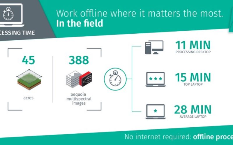
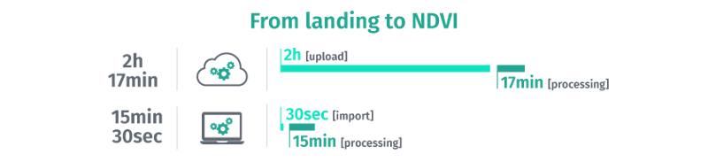
With the onset of cloud-based apps and map processing, some assume being in the cloud is the fastest way to get results. However, you need to consider your access to a good connection, queue time, processing time, etc.

Pix4Dag desktop processing is unlimited, you can process as many images and as many datasets as you want.

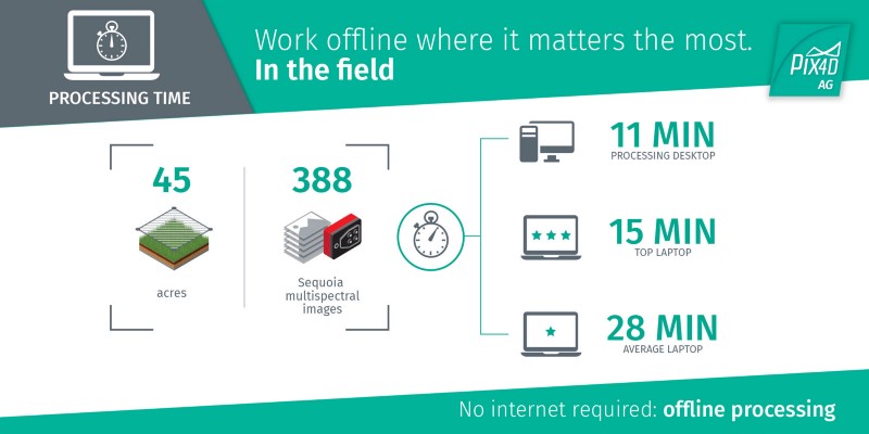
Desktop is essential because it offers processing in the field anytime, when a poor connection renders even cloud uploading painful. However, the cloud has tremendous value where it makes sense in agriculture. It’s a powerful ag ally when it comes to sharing, and that’s why we also have Pix4Dag Cloud, the perfect platform to ensure everyone is informed, and indispensable when you do not have your own processing hardware.


For the Part 3 in this series, we’ll touch on all the analysis options Pix4Dag offers. Stay tuned.

 Read Part 1: How quickly can you go from landing to processing?

Categories: Remote Sensing

About Author

GIS Resources

GIS Resources is an initiative of Spatial Media and Services Enterprises with the purpose that everyone can enrich their knowledge and develop competitiveness. GIS Resources is a global platform, for latest and high-quality information source for the geospatial industry, brings you the latest insights into the developments in geospatial science and technology.

Write a Comment

Your e-mail address will not be published.
Required fields are marked*

This site uses Akismet to reduce spam. Learn how your comment data is processed.