
Archive

Cyient to Host Hackadrone 2018–India’s First UAV Hackathon
Participation open to developers, start-ups, college students, and independent software programmers from across the country Hyderabad, India, Dec. 6, 2017/PRNewswire/ — Cyient, a global provider of engineering, manufacturing, geospatial, network, and
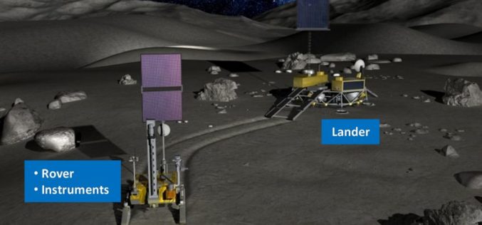
JAXA and ISRO Signs Implementation Arrangement of Joint Lunar Polar Exploration
Japan, December 6, 2017 – Japan Aerospace Exploration Agency (JAXA) and Indian Space Research Organization (ISRO) signed the Implementation Arrangement (IA) concerning a joint study of Lunar Polar Exploration. JAXA and ISRO
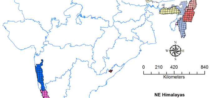
Geological Survey of India to Complete Landslide Susceptibility Mapping in 2018
Kolkata, December 6, 2017 (IANS) : The Geological Survey of India (GSI) is set to complete generation of Landslide Susceptibility Maps – covering an area of 1.71 lakh sq km
UrtheCast Announces Committed Revenue Backlog for UrtheDaily Constellation in Excess of C$100 Million
Multi-year revenue commitments support development of disruptive, best-in-class UrtheDailyTM Constellation Vancouver, December 5th, 2017 – UrtheCast Corp. (TSX:UR) (“UrtheCast” or the “Company”), is pleased to announce it has now signed binding data subscription
UrtheCast and Twenty First Aerospace Technology Sign a Strategic Partnership for UrtheDaily Constellation in China
Vancouver, December 5,2017 – UrtheCast Corp. (TSX:UR) (“UrtheCast” or the “Company”), and Twenty-First Century Aerospace Technology Co. Ltd(“21AT”),Chinas largest independent commercial satellite operator and non-governmental investor in remote sensing satellite systems, today announced a

TerraGo Edge Version 4.2 Enhances Field User Experience and Mobile Mapping
December 4, 2017 – TerraGo is happy to announce the availability of TerraGo Edge Version 4.2 and any app created with the TerraGo Magic zero-code app platform includes enhancements to the user experience that accelerate

Mapbox Acquires Fitness AR to Deepen its Focus on Augmented Reality
Team behind top AR app will lead rapidly expanding Mapbox team focused on design and developer innovation SAN FRANCISCO, Dec. 1, 2017 /PRNewswire/ — Mapbox, the mapping and location platform for developers, today

UrtheCast and Beijing Space View Technology Sign Strategic Cooperation Agreement for the Global Distribution of Their Respective Portfolios
Madrid, Spain, December 4, 2017 – UrtheCast Corp. and its subsidiary, the Earth Observation company Deimos Imaging, today announced the signing of a strategic cooperation agreement with Beijing Space View Technology

EarthServer: More Than 1 Petabyte Analysis-Ready Data
November 2017 – EarthServer, the European Union Big Data initiative, has reached the next milestone: Today in the second phase extending through April 2018, the Italian data provider MEEO S.R.L.
Esri Signs Global Enterprise Agreement with Airbus Defence and Space
New Agreement Gives Airbus Defence and Space Online Spatial Analytics for Faster, More Cost-Effective Operations November 30, 2017 – Redlands, California—Esri, the global leader in spatial analytics, today announced that it
