
Archive

Construction of the FIFA World Cup Stadiums From Space
Deimos Imaging has released a story map with satellite imagery collected by them and their partners showing the construction and refurbishing of the World Cup stadiums.
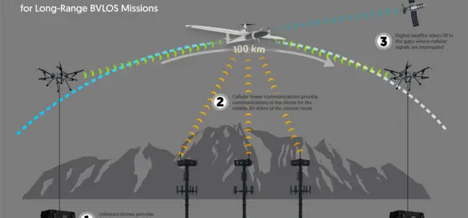
Kongsberg Geospatial Airspace Awareness Software to be used by 3 of the 4 Teams Selected by Transport Canada for BVLOS Flight Trials in Canada
Ottawa, CA, June 12, 2018 – Kongsberg Geospatial Ltd., an Ottawa-based geospatial and Air Traffic Management visualisation software company announced today that its IRIS technology will be used by three
Hexagon Introduces HxGN MineOperate UG Pro for Miners
JUNE 13, 2018 – Hexagon AB, a global leader in digital solutions, today revealed HxGN MineOperate UG Pro at HxGN LIVE 2018, its digital technology conference. UG Pro is a
Topcon Releases New Edition of MAGNET Software Suite for Optimized Workflow
LIVERMORE, Calif., U.S./ CAPELLE A/D IJSSEL, the Netherlands – June 12, 2018 – Topcon Positioning Group announces the release of the latest edition of its suite of software solutions —
Hexagon Announces Xalt, A Radical New Approach for Harnessing the Untapped Potential of IoT Data
June 13, 2018 – Hexagon AB, a global leader in digital solutions, today announces Xalt, a powerful new framework for accelerating digital transformation – fast-tracking a customer’s ability to fully leverage

SimActive Software for Precision Agriculture in Brazil
June 12, 2018 – SimActive Inc. is proud to announce use of its software for precision agriculture in Brazil by Portal Produtos Agropecuários Ltda (Portal). Drone data is transformed into

Headwall Integrates Hyperspectral and LiDAR Aboard UAV Platforms
Enabling Remote Sensing Capabilities From Civil Infrastructure Inspection to Crop Monitoring BOLTON, MA, JUNE 11 – Headwall has introduced advanced sensor payloads consisting of hyperspectral sensors and LIDAR for deployment
NAKANIHON and RIEGL to Give Joint Presentation on Helicopter-based Airborne Bathymetric LiDAR Systems
19th JABLTCX workshop, June 26-28, 2018 Providence, Rhode Island, USA: NAKANIHON and RIEGL to Give Joint Presentation on Helicopter-based Airborne Bathymetric LiDAR Systems Horn, June 7, 2018 – After successfully integrating and mobilizing a

Boundless Server Enterprise Now Available as Managed Cloud Service
Boundless Server Enterprise as a Managed Service Enables Infrastructure and IT Cost Savings While Delivering Exceptional Application Performance with Elastic Scalability St. Louis, MO – June 5, 2018 – Boundless, the leader
Trimble RealWorks Announces Performance and UI Enhancements
Batch processing, visualization tools, and improved multi-core support streamline point cloud workflows for geospatial professionals Trimble® RealWorks® has announced a new version of the industry’s leading all-in-one point cloud software platform.
