
Posts From GIS Resources

Leica Geosystems Acquires M&P Survey in the UK
In March 2016, Hexagon Geosystems, business division of Hexagon including Leica Geosystems, acquired M&P Survey Equipment Limited – one of the UK’s leading Leica Geosystems distributors. Since then, Hexagon Geosystems

Jamaica Acquired Satellite Imagery of the Island to Boost Spatial Data Infrastructure
Jamaica – According to the recent news reported by the Jamaica Observer, the National Spatial Data Management Division (NSDMD) in the Ministry of Economic Growth and Job Creation has informed

Airborne LiDAR to Throw Light on Rajgir Hill’s History
Kolkata,Nov 7, 2016- IANS – Indian archaeologists plan to deploy high-end scanning lasers on airborne platforms to survey the archaeological evidence, flora and fauna in the ancient Rajgir hills in
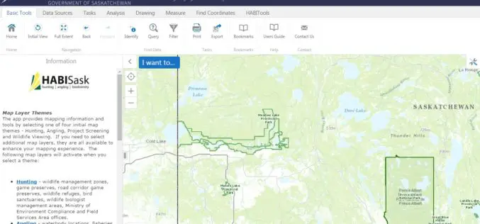
Government of Saskatchewan Launches New Hunting, Angling and Biodiversity Mapping Tool
The Ministry of Environment, Saskatchewan launched a new client-centred, online mapping tool called HABISask (Hunting, Angling and Biodiversity Information of Saskatchewan) that combines new and existing information on hunting, angling,

Trimble’s New SketchUp Viewer for Microsoft HoloLens Enables Users to Inhabit and Experience Designs
SketchUp with Mixed Reality Ushers in New Paradigm: Experiential Design Review LAS VEGAS, Nov. 7, 2016—Trimble (NASDAQ:TRMB) launched today its SketchUp Viewer for Microsoft HoloLens. The new mixed-reality solution allows

Drone That Can Create a Perfect 3D Map of Any Town – And May Help Set up 5G Networks
London, According to recent news reported by the PTI, Remote-controlled drones can be used to create an accurate 3D model of an urban area and design wireless networks, scientists say,
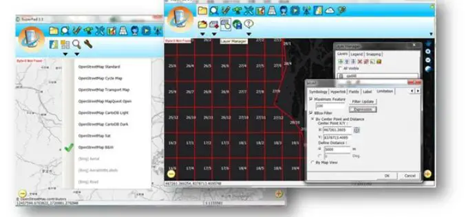
Collect High-Precision Data in the Field with latest SuperPad 3.3!
The global leading GIS software and solution provider, Supergeo Technologies Inc., is pleased to announce the latest release of SuperPad 3.3.4797. SuperPad is the mobile GIS software designed for surveying

Kongsberg Geospatial & AirMap Deliver Real-Time Airspace Awareness and Tools for Drone Flight Beyond Visual Line of Sight
Ottawa, CA: Kongsberg Geospatial, an Ottawa-based developer of real-time, mission critical, geospatial visualisation software, and AirMap, the leading airspace management platform for drones, announced today that they will be delivering
Esri Boosts Higher Education in Ethiopia
Company Donates Cloud-Based GIS Solutions to More Than 30 Schools Redlands, California—Smart mapping leader Esri announced an agreement between Esri Eastern Africa Limited and the Federal Democratic Republic of Ethiopia

Election Commission of Malaysia Selects SuperSurv for Efficient Spatial Data Collection
Supergeo is delighted to announce that with the assistance from Supergeo’s partner in Malaysia, Suruhanjaya Pilihan Raya Malaysia (SPR Malaysia, lit. Election Commission of Malaysia) has recently chosen SuperSurv 3.3 as the
