
Business
Esri Managed Cloud Services Receives Census Bureau Authorization
Redlands, California— Esri Managed Cloud Services has achieved an agency Authorization to Operate (ATO) at the moderate level from the US Census Bureau. Esri worked with the bureau to build and

Indoor Mapping Project Attracts Funding from Google
School of Information Studies (iSchool), Syracuse University, Assistant Professor Yun Huang has received funding from Google’s Faculty Research Awards Program that will help her continue research on an indoor mapping project. The

Drone Connector Now Features Over 700 Professional Drone Operators in Over 90 Countries
senseFly’s global service network, Drone Connector, now features over 700 professional drone operators, which it connects with organisations that require their help to produce geo-referenced imagery and data products. Created

Counter-UAV System from Airbus Defence and Space Protects Large Installations and Events from Illicit Intrusion
Sensor Data Fusion offers countermeasures against small drones Airbus Defence and Space has developed a Counter-UAV System which detects illicit intrusions of Unmanned Aerial Vehicles (UAVs) over critical areas at

Bring Spatial Skills to Canadian Children, Become a GIS Ambassador
Geospatial professionals, educators & students encouraged to help youth develop problem-solving skills using technology Spatial thinking involves understanding the relationships between objects based on their location and learning the importance

INTERGEO 2015 Ends Successful – Geo-Sector Agrees: Geoinformation is The International Language Of Decision-Makers
Stuttgart, 17 September 2015 – Geoinformation is the global language that decision-makers all understand. This places the geoinformation sector, with its technologies and solutions, in a key position to deliver

Esri Photo Survey Speeds Property Surveys
ArcGIS for Local Government Solution Leverages Street-Level Photos to Simplify Survey Data Collection Redlands, California—To eliminate blight and revitalize neighborhoods, many local governments use large teams of volunteers to evaluate

Hexagon Geosystems, Hexagon Geospatial to host inaugural National Mapping & Cadastre Authorities Summit
Summit addresses new challenges faced by National Mapping Agencies and Cadastre Authorities and offers solutions to overcome the issues 15 September 2015. Hexagon Geosystems and Hexagon Geospatial will host a summit
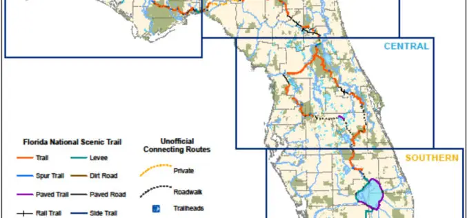
New Sunshine State Maps Add U.S. Forest Service Data
Recently released US Topo maps for Florida now feature more trails using data provided by the U.S. Forest Service as well as trail information from other federal, state and private

MAPPS Comments on Pipeline Safety
Calling for enhanced mapping and location data for the Nation’s pipelines, MAPPS submitted a statement on Friday to the Surface Transportation and Merchant Marine Infrastructure, Safety, and Security Subcommittee of