
Remote Sensing
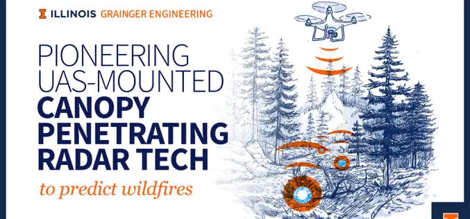
Illinois Scientists Advance Canopy-Penetrating Radar for Fire Prevention
Wildfires are unpredictable disasters that spread rapidly, leaving destruction in their path. Traditional remote sensing methods struggle to penetrate dense forest canopies, making it difficult to detect dry vegetation and

Three Advanced Iran Remote Sensing Satellites to Boost National Space Program
Iran is set to unveil three cutting-edge, indigenous satellites, significantly enhancing its capabilities in space technology. The satellites – two upgraded remote sensing satellites, Pars-1 and Pars-2, and the Navak
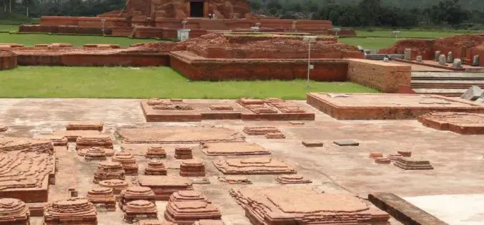
Remote Sensing Archaeology Locates Ancient Valabhi Town in Gujarat
A groundbreaking study has utilized remote sensing archaeology to uncover the location of the ancient town of Valabhi in Gujarat, India. Valabhi, once the thriving administrative capital of the Maitraka

USGS Unveils First Map of Geologic Hydrogen in the U.S.
The U.S. Geological Survey (USGS) has released a groundbreaking map highlighting potential regions for Geologic Hydrogen in the contiguous United States. This innovative tool represents a significant step forward in

PRSC-EO1: Pakistan’s First Indigenous Electro-Optical Satellite Launched
Pakistan has achieved a significant milestone with the successful launch of its first indigenous Electro-Optical satellite, PRSC-EO1. The satellite was launched on January 17, 2025, from China’s Jiuquan Satellite Launch

Laos Embraces Satellite Technology for Carbon Credit Feasibility
Laos is taking significant steps towards sustainable development by leveraging satellite remote sensing to evaluate carbon stocks across nine forest areas, covering 170,556 hectares. This initiative, led by the Ministry

Uzma Berhad Launches Malaysia’s First High-Resolution Earth Observation Satellite – UZMA SAT-1
Uzma Berhad, a prominent Malaysian oil and gas services provider, has successfully ventured into space technology with the launch of its first Earth observation satellite, UZMA SAT-1. This milestone was

UNL and USDA Collaborate on a Web-Based Soil Sampling Tool
A collaborative effort between the University of Nebraska–Lincoln (UNL) and the U.S. Department of Agriculture (USDA) has led to the development of the Soil Sample Planning Organizer Tool (SSPOT), a

Hyperspectral Plastic Detection for Riverine Cleanup
Plastic pollution in rivers is a growing environmental challenge. With millions of tons of plastic waste flowing into oceans annually, the need for effective monitoring and cleanup has never been
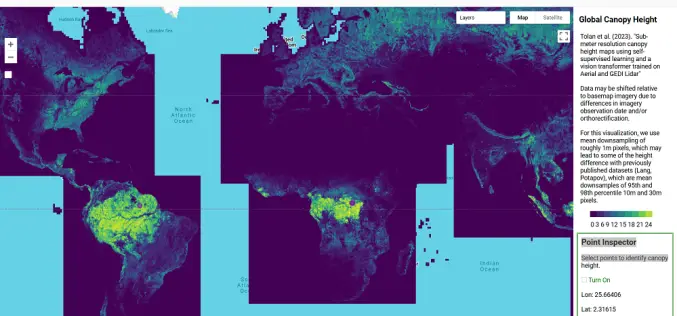
AI-Powered Tree Canopy Map by Meta and WRI
Meta, in collaboration with the World Resources Institute (WRI), has launched an advanced AI-powered Tree Canopy Map that provides unparalleled accuracy and detail in monitoring forests worldwide. By analyzing trillions
