Hyderabad CM Orders LiDAR Survey to Prevent Encroachments on Water Bodies
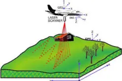
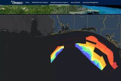
Hyderabad Chief Minister A. Revanth Reddy has instructed officials to conduct an extensive LiDAR survey of lakes, nalas (drains), and other water bodies to curb illegal encroachments. The advanced remote-sensing technology will help create precise three-dimensional maps, allowing authorities to identify areas under threat and plan strategic interventions.
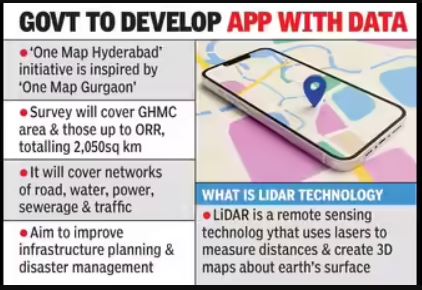
Such a survey aligns with the broader “One Map Hyderabad” vision, which aims to consolidate infrastructure data across Greater Hyderabad Municipal Corporation (GHMC) and areas up to the Outer Ring Road (ORR), spanning approximately 2,050 sq km. With LiDAR survey data, officials can accurately demarcate Full Tank Levels (FTL) and buffer zones essential for protecting water bodies—an effort already underway through HYDRAA’s mapping and demolition initiatives.
Also Read – Scanning Hallstatt: RIEGL LiDAR Transforms Exploration of a World Heritage Landscape
Essentially, the CM’s directive leverages LiDAR to modernize the fight against encroachment, ensuring Hyderabad’s water ecosystems are mapped, monitored, and safeguarded with precise technological tools. LiDAR will provide clear, actionable data to reinforce HYDRAA’s mandate across the city and its outskirts.
To translate this directive into impact, the government can prioritize these actions:
- Fast-track the tendering and rollout of the LiDAR survey, especially in flood-affected and encroached areas.
- Integrate the survey outputs into urban planning and enforcement systems—linking them with satellite data, cadastral maps, and FTL records.
- Use the gathered LiDAR insights to guide HYDRAA’s future demolition drives and restoration plans, making interventions more timely and targeted.