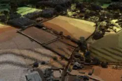
The Indian Railway’s Northeast Frontier Railway (NFR) zone is set to conduct an Airborne LiDAR Survey on the Lumding to Badarpur hill section. This advanced survey will take place during and after the monsoon season to assess the geological and soil conditions of this critical railway corridor, which is often affected by landslides and track damage due to heavy rains.
The survey will help to analyze the region’s soil strata, slope stability, natural faults, water accumulation, and hill toe stability, particularly during and after the monsoon season.
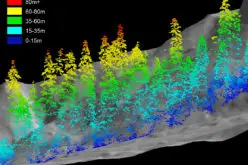
The survey will cover an 80-kilometer stretch between kilometer 45 and kilometer 125. It has been awarded to M/S Garudauav Soft Solutions Private Limited, a company based in Noida, and will utilize a variety of non-invasive sensors, including LiDAR, optical photogrammetry, infrared mapping, and ground-penetrating radar. These technologies will capture detailed topographical data and monitor the geophysical landscape and subterranean environment.
The data collected will be processed with artificial intelligence to identify and analyze potential failure areas, enhancing the preventive maintenance of the railway track without significant human intervention. This proactive approach aims to ensure the safety, efficiency, and reliability of the railway operations in this region.

A LiDAR (Light Detection and Ranging) system beams light out and then precisely monitors the timing of reflections to map and track objects within its detection range. A LiDAR instrument principally consists of a laser, a scanner, and a specialized GPS receiver. Airborne LiDAR offers several advantages over traditional surveying methods, including rapid data collection over large areas, high accuracy, and the ability to penetrate vegetation to map the ground surface.
Source: NeIndiaBroadcast and Sentinel Assam
Also Read –
India Plans for Airborne Radar Survey of Andaman and Nicobar Islands