Impact Of Advancements in Computational Mathematics on Geospatial Technology
Advancements in geospatial technology have led to incredible progress in various sectors, from urban planning to environmental management. Among the many factors contributing to this progress, computational mathematics takes center stage as a driving force in the development and implementation of geospatial applications.
Computational mathematics, a branch of applied mathematics, combines the use of advanced mathematical models with powerful computing techniques to solve complex real-world problems. For those interested in exploring these advanced mathematical models further, a math solver can be an invaluable tool in understanding and applying these complex concepts. In the context of geospatial technology, computational mathematics enables the efficient handling of massive datasets, complex algorithms, and sophisticated visualization tools necessary for precise and accurate representation of spatial information.
The synergy between geospatial technology and computational mathematics has significantly enhanced the capabilities of various technology-based disciplines across science and industry. This collaboration has resulted in various breakthroughs in remote sensing, geographical information systems (GIS), and location-based services, among others.
Fundamentals of Geospatial Technology
Geospatial technology plays a pivotal role in the analysis and understanding of spatial relationships and complex datasets, ultimately helping to solve real-world problems. Here, we focus on three key aspects of geospatial technology: Geographic Information Science (GIS) and Geodesy, Remote Sensing and Earth Observation, and Geospatial Data and Analytics.
Geographic Information Science (GIS) and Geodesy
Geographic Information Science (GIS) is a multidisciplinary field that combines computational techniques with geospatial data to analyze, model, and visualize patterns across geographical spaces. GIS enables users to create interactive maps, run geospatial analysis, perform data-intensive computing, and undertake a wide variety of modeling tasks. In essence, GIS serves as the backbone for a wide variety of applications, ranging from urban planning to environmental monitoring and natural resource management.
Geodesy is the study of Earth’s shape, size, and gravitational field, and it underpins the accurate representation of spatial data. Geodesists leverage mathematical models, observations, and satellite technologies to define coordinate systems like the Global Positioning System (GPS). The integration of geodetic data within GIS systems is fundamental for enhancing the accuracy and reliability of geospatial analysis.
Remote Sensing and Earth Observation
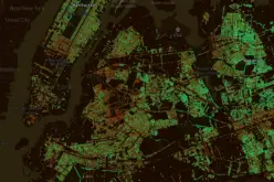
Remote sensing involves the acquisition, processing, and interpretation of data from airborne or satellite-borne sensors to study Earth’s physical properties and environmental phenomena. Remote sensing techniques include both passive (e.g., multispectral and hyperspectral imaging) and active (e.g., Lidar and Radar) sensing modalities, which generate high-resolution geospatial datasets.
Earth observation is a subfield of remote sensing that focuses on global-scale monitoring of environmental and human-induced changes. Earth observation supports various applications, including climate change, disaster management, and biodiversity conservation. Combining GIS with remote sensing and Earth observation allows users to derive valuable insights into complex spatial relationships and model the consequences of different scenarios.
Geospatial Data and Analytics
Geospatial data refers to the information related to geographical locations and features, which can be represented in different formats, such as vector, raster, or point-cloud data. Geospatial datasets can originate from various sources, including remote sensing, GPS, and user-generated data (e.g., social media). Organizing, managing, and processing these disparate sources of information often involve dealing with big data challenges due to the volume, variety, velocity, and veracity of the data.
Data analytics includes the techniques, algorithms, and visualization tools used to make sense of the geospatial data and uncover hidden patterns. In the context of geospatial technology, data analytics may involve machine learning, statistical analysis, and spatial data analysis. Integrating data analytics with GIS, remote sensing, and geodetic measurements is crucial for making informed decisions and better understanding the multi-faceted relationships in our world.
Computational Methods in Geospatial Technologies
Machine Learning and Deep Learning
In recent years, machine learning and deep learning have emerged as key components of advancements in geospatial technologies. These computational methods empower researchers and analysts to efficiently process vast amounts of geospatial data and extract useful insights. With techniques such as supervised learning, unsupervised learning, and reinforcement learning, machine learning algorithms have facilitated various applications, including:
- Classification: Sorting geospatial data into distinct categories based on specific features.
- Regression: Predicting continuous values for better decision-making.
- Clustering: Grouping geospatial data points that share similar characteristics.
On the other hand, deep learning, which is a subset of machine learning, employs neural networks to progressively enhance the accuracy of solutions. As a result, deep learning has driven progress in areas like object detection, land cover mapping, and remote sensing.
High-Performance Computing and Cloud Computing
High-performance computing (HPC) and cloud computing are integral to tackling the computational challenges in geospatial technologies. HPC delivers the computational power necessary to process large-scale geospatial datasets within a reasonable time frame. This capability is achieved through parallel computing, which leverages multiple processors or computing nodes to work simultaneously on a problem.
In addition, cloud computing providers have enabled geospatial data storage, processing, and analysis at scale. This has allowed researchers and organizations to:
- Access cost-effective and flexible computing resources
- Enhance collaborative workflows among teams
- Utilize managed services for data analysis and visualization
Furthermore, cloud-based APIs (Application Programming Interfaces) have simplified the integration of new computational methods into existing geospatial workflows.
Sparking Insights with Spark and Scientific Workflows
Apache Spark is an open-source computing framework that offers an excellent platform for large-scale data processing. It is designed to efficiently handle complex geospatial analyses with speed and accuracy. Spark’s key features include:
- In-memory processing: Minimizing the need for data movement between memory and disk, leading to faster computations.
- Fault-tolerance: Ensuring data reliability through built-in data replication.
- Support for various programming languages: Enabling developers to write applications in Java, Python, Scala, and R.
Scientific workflows are a series of interconnected computational tasks designed to gracefully manage the flow of data between processes. They have become essential tools for reproducibility and scalability in geospatial technologies. Popular workflow systems like Pegasus and Kepler offer user-friendly graphical interfaces and flexible scripting languages for creating and sharing complex workflows.
In conclusion, computational methods are playing a central role in shaping advancements in geospatial technologies. Through the combined power of machine learning, deep learning, high-performance computing, cloud computing, Spark, and scientific workflows, researchers can harness the full potential of geospatial data and revolutionize a wide range of applications.
Applications of Computational Mathematics in Geospatial Technologies
Environmental Monitoring and Sustainable Development
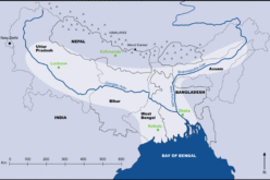
Computational mathematics plays a crucial role in geospatial analysis for environmental monitoring and sustainable development. By processing large datasets from various sources, such as remote sensing, climate change models, and geographical information systems (GIS), computational methods allow researchers to better understand spatial patterns and trends in the environment.
For example, advanced algorithms can analyze satellite imagery to detect deforestation and map out changes in land use over time. This information is invaluable for decision-makers, as it helps in creating effective policies targeting sustainable development and mitigating the impact of climate change. Additionally, the continuous development of new sensors and data collection methods contributes to the increasing accuracy and reliability of geospatial data.
Urban Planning and Disaster Management
In the realm of urban planning, computational mathematics greatly enhances the capabilities of geomatics by providing efficient methods for processing large amounts of spatial data. This enables urban planners to identify optimal locations for infrastructure development, analyze transportation networks, and evaluate the impact of their decisions on nearby communities.
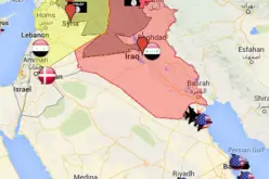
Furthermore, computational mathematics has been instrumental in advancing disaster management efforts. By integrating geospatial data with predictive models, authorities can better prepare for and respond to natural disasters such as floods, earthquakes, and wildfires. For instance, through real-time mapping and analysis of spatial patterns, emergency response teams can identify the most vulnerable areas and allocate resources effectively, ultimately saving lives and reducing property damage.
Advancements in Precision Agriculture
The agriculture sector has been revolutionized by the growing capabilities of geospatial technologies, particularly due to the integration of computational mathematics in precision agriculture. These advancements enable farmers to optimize their use of resources, such as water and fertilizers, by applying them selectively based on spatial patterns and specific needs of different areas.
Some examples of innovative applications include:
- Remote sensing: Satellites and drones capture high-resolution imagery, which helps assess crop health, detect pests and diseases, and estimate yield.
- GIS applications: Farmers can create detailed maps of their farms, revealing variations in soil and environmental conditions, and thus informing agronomic decisions.
- Variable-rate technology: Equipment like GPS-guided sprayers and automated irrigation systems enable the precise application of inputs based on geospatial data.
These technological advancements, facilitated by computational mathematics, contribute to improving the efficiency and sustainability of agricultural practices, ultimately resulting in increased food production while minimizing environmental impacts.
Emerging Trends in Geospatial Technology
Integration of IoT and Geospatial Workflows
The integration of the Internet of Things (IoT) with geospatial workflows has created a massive impact on various industries. IoT devices—such as sensors, GPS devices, and drones—acting as sources of data have significantly increased the quantity of remote sensing data available.
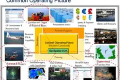
Geospatial intelligence has benefited from this influx of IoT-enabled geospatial data. The fusion of IoT and geospatial workflows has allowed for real-time monitoring and decision-making based on accurate, up-to-date maps and models. Advanced computing architecture plays a critical role in processing, analyzing, and interpreting the massive volume of data from both IoT and geospatial workflows.
GeoAI and the Future of Spatial Analytics
Artificial Intelligence (AI) has emerged as a key component in the field of geospatial technology, giving rise to the concept of GeoAI. GeoAI combines geospatial intelligence and AI to create powerful spatial analytics tools. These tools have enhanced the accuracy and efficiency of data analysis, making complex problem-solving more manageable.
The fusion of GeoAI and traditional spatial analytics has significantly boosted capabilities in areas such as disaster management, urban planning, and natural resource management.
Synergizing Geospatial Data with Social Sciences and Medicine
The increasing accessibility of geospatial data has opened new avenues for collaboration between the geospatial industry and the social sciences and medicine sectors. These interdisciplinary connections offer promising opportunities to address complex and pressing societal challenges.
- Urban planning: By integrating geospatial data with social science research, urban planners can better understand factors such as population distribution, land use patterns, and spatial inequalities. This understanding enables the development of sustainable and inclusive cities.
- Epidemic tracking and public health: Geospatial data in medicine can facilitate disease tracking, allowing experts to monitor and predict the spread of diseases and identify high-risk areas. This information can be used to develop targeted public health strategies and allocate resources more effectively.
These emerging trends in geospatial technology underscore the transformative power of computational mathematics. By integrating AI, IoT, and interdisciplinary collaborations, these advancements stand to improve decision-making and drive meaningful change across diverse sectors.