
Maxar’s Raptor Software Sets New Standard for GPS-Denied Drone Navigation
In an era where GPS interference and jamming pose significant challenges to autonomous systems, Maxar Intelligence has unveiled a powerful solution—Raptor. This first-of-its-kind software suite is specifically designed to enable GPS-denied drone navigation, allowing autonomous aerial platforms to operate reliably even when GPS signals are blocked, degraded, or unavailable. Raptor empowers drones to navigate complex environments such as dense urban areas, contested military zones, or remote terrains where traditional navigation methods fall short.
Expertise: Pioneering Vision-Based Navigation
Maxar, renowned for its geospatial intelligence, leverages its extensive 3D terrain data, spanning over 90 million square kilometers, to enable drones to navigate using only their onboard cameras. This vision-based approach eliminates the dependency on GPS signals, allowing for accurate ground coordinate extraction in real-time.
Experience: Proven Performance in Challenging Conditions
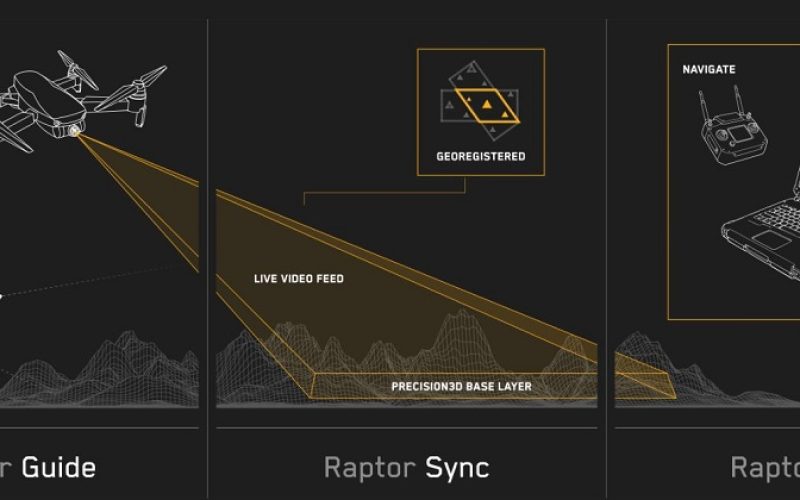
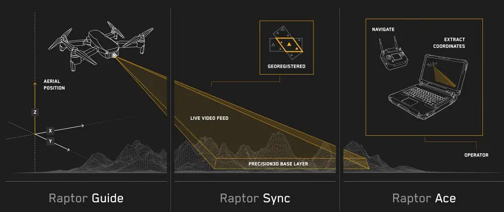
Raptor comprises three integrated components to achive GPS-Denied Drone Navigation:
- Raptor Guide: Provides vision-based positioning with an accuracy of less than 10 meters RMSE.
- Raptor Sync: Georegisters drone video feeds with Maxar’s 3D data, achieving ground coordinate accuracy within 3 meters.
- Raptor Ace: Operates on standard laptops, enabling operators to extract real-time coordinates from aerial video feeds with high precision.
Also Read – Predicting Flood Impacts with Generative AI and Physics-Based Models
These tools have demonstrated effectiveness in various scenarios, including night operations and low-altitude flights, without the need for additional hardware.
Trustworthiness: Enhancing Operational Resilience with GPS-Denied Drone Navigation
Raptor’s design ensures resilience against GPS jamming, a common issue in modern conflict zones. By relying on visual data and Maxar’s up-to-date terrain models, drones can maintain operational integrity even when GPS signals are compromised. This capability is crucial for military applications and has potential benefits for humanitarian and commercial operations.
Authoritativeness: Leading the Future of Autonomous Systems
Peter Wilczynski, Chief Product Officer at Maxar Intelligence, emphasizes Raptor’s transformative impact:
“By eliminating reliance on GPS, Raptor software unlocks the full potential of autonomous systems—from powering truly joint multi-domain operations as part of a digital battlefield to large-scale delivery systems in urban areas where knowing the precise coordinates of your drop-off location is critical to getting the job done.”
Maxar’s commitment to innovation positions Raptor as a pivotal solution in advancing autonomous system capabilities across various sectors.
Source: Maxar, roboticstomorrow.com, Business Insider