SuperGIS Helps National Research Council of Italy to Analyze Earth System

 Supergeo Technologies, the global leading GIS software and solution provider, announced that Institute of Geosciences and Earth Resources, National Research Council of Italy (CNR) utilizes SuperSurv and SuperGIS Desktop to collect and process various GIS data to examine the changes and status of the Earth system.
Institute of Geosciences and Earth Resources aims at the studies of the geological processes affecting the Earth system through geodynamic, geochemical, and geophysical studies. The institute helps Italy deal with multiple natural or artificial impacts on land use.
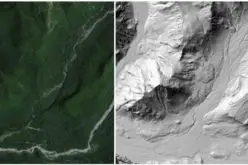
With SuperSurv, the professional GIS mapping app for iOS and Android, researchers are able to integrate multiple geospatial data. Its offline mode can help field workers collect and map spatial data in severe environments, like mountains, forests or mines, which are especially important for geological research.
All the collected data can be further processed by SuperGIS Desktop. With the powerful GIS software, researchers can visualize and digitize geospatial data quickly and get the analyzed results by diverse analysis tools to see the procedure occurring both in the interior and at the surface of the Earth, as the policy-making reference for governments.
By using SuperSurv and SuperGIS Desktop, the studies of earth system can be conducted effectively, and the captured data can be easily understood and shared. In this way, Institute of Geosciences and Earth Resources is able to provide the fundamental knowledge for the Nation in responding global changes.
Get the Free Trial
SuperGIS Desktop
http://www.supergeotek.com/download_6_desktop.aspx
SuperSurv for Android
https://play.google.com/store/apps/details?id=com.supergeo.asd.supersurvlite.SuperSurv
SuperSurv for iOS
https://itunes.apple.com/us/app/supersurv/id734191604?mt=8