
Tag "geospatial"
Esri Offers Customers On-Demand Deployment and Managed Services in the Cloud
November 30, 2016 – Redlands, California—At this year’s AWS re:Invent, global smart-mapping leader Esri announced that customers can now deploy select ArcGIS licenses from Amazon Web Services (AWS) Marketplace instantly, using

Kolhapur Municipal Corporation to use GIS for Development Planning
KOLHAPUR, Maharashtra: According to recent news by ToI, the Kolhapur Municipal Corporation (KMC) is planning to harness the power of Geographic Information System (GIS) technology for planning and determining land

TerraGo Joins Trimble Developer Partner Program and Includes Trimble GNSS Direct SDK in Mobile Products
TerraGo Edge® and TerraGo Magic® now include the Trimble® GNSS Direct SDK enabling professional-grade positioning with consumer ease of use for all types of field data collection, engineering, asset inspections
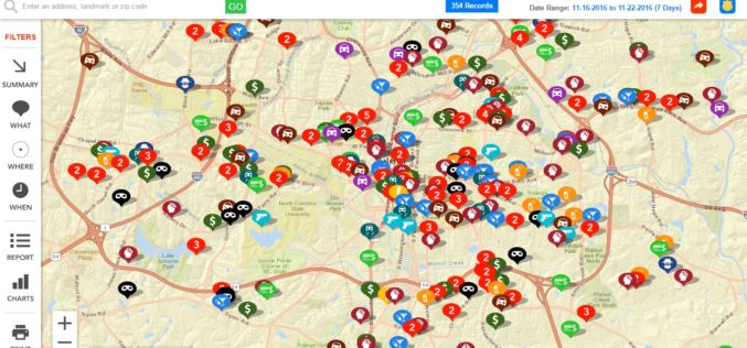
Raleigh Police Department Launches Crime Mapping Tool
Raleigh, North Carolina Nov. 21, 2016- The Raleigh Police Department has launched an online crime-mapping tool that helps people to learn of crimes reported in areas that are of interest to them.
Supergeo Announces Partnership with GPS Lands Indosolutions in Indonesia
Supergeo Technologies Inc., the global GIS software and solution provider, announces the partnership with PT. GPS Lands Indosolutions in Indonesia. Headquartered in Jakarta, PT. GPS Lands Indosolutions is a company
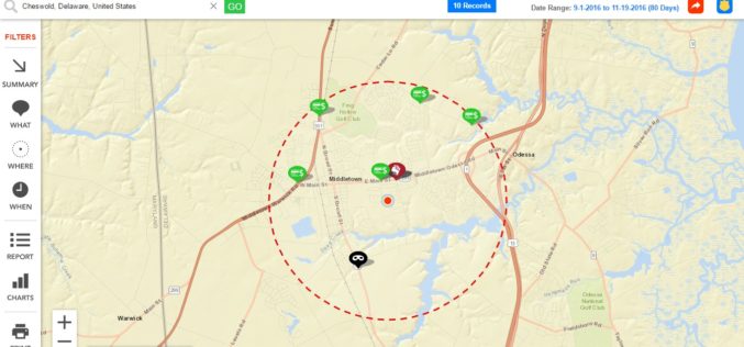
Delaware State Police Announces Crime Mapping Website
Delaware, USA Nov. 17, 2016 – Crime mapping is one tool that serves that purpose and is an extraordinary example of Delaware State Police (DSP) effort to leverage technology to

Pitney Bowes Geospatial API Providing Location Intelligence for Data Analytics Now Available as a SaaS Subscription Offering on AWS Marketplace
STAMFORD, Conn., November 17, 2016 – Pitney Bowes (NYSE:PBI), a global technology company providing innovative products and solutions to power commerce, today announced that the Pitney Bowes Geospatial API is

Kenya to Have its First Geospatial Data Centre
According to recent news by IT Web Africa, Kenya could have its its first geospatial data centre by June next year, proposes to cost of Kshs 800 million (US$8m), to

East View Launches MapVault – Online Access to Authoritative Raster Maps
MINNEAPOLIS, Minn. – East View Geospatial (EVG) has launched MapVaultTM, a web-based subscription service providing access to a global collection of raster mapping. The scope of the collection that EVG
Hexagon Geospatial Announces Partnership with HERE
HERE to provide map data and location services for Hexagon Smart M.App developers NORCROSS, GA–(Marketwired – November 15, 2016) – Hexagon Geospatial and HERE have signed an agreement that will
