
Tag "Ordnance Survey"
Is Britain on the move?
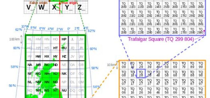
Australia has recently announced a 1.8m shift in its mapping coordinates, to compensate for the country’s 7.5cm shift north each year. Inevitably the question is why, and could the same

Are you building the next Pokemon Go? Apply to Geovation now to secure funding for your GeoTech start-up
Geovation, an Ordnance Survey (OS) initiative supporting corporations, SMEs, start-ups and individuals using geospatial technology and data to create innovative new products and services, invites applications for the next batch of
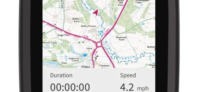
CompeGPS and Ordnance Survey Team Up to Produce the ‘OS Range of GPS Units’
Ordnance Survey (OS) and CompeGPS are pleased to announce a new partnership to release a range of outdoor activity GPS units. The exciting move is being made ahead of the leading
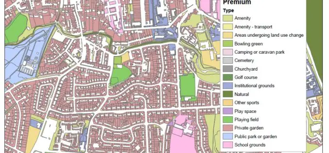
New Dataset of Accessible Greenspace for Scotland
A new digital map of every publicly accessible greenspace in Scotland will be released in March 2017. Recently the Ordnance Survey (OS) and the Scottish Government released an update on the project

London Mapped in Original OS Style
21 June 2016 – Today Ordnance Survey (OS) is mining data used daily at all levels of national and local government, by the emergency services and large and small businesses. That data

New 3D Modelling Application to Save Money and Time
The most accurate and up-to-date geographic data now available for the first time in new application suitable for BIM projects. OS Model Builder is a new visualisation tool that can
OS Reveals Winning Ideas That Will Improve our Relationship with Water
Last December Ordnance Survey, with support from Southern Water, United Utilities, the Environment Agency and The Department for Environment, Food and Rural Affairs (Defra), launched its latest Geovation Challenge, asking developers
Ordnance Survey committed to European Smart City standards
Ordnance Survey is to create a Smart City standards-based technologies business framework for the European Union’s ESPRESSO project. ESPRESSO is being led by the Open Geospatial Consortium, and OS, working closely
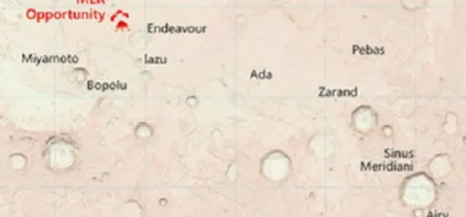
Ordnance Survey Has Created Map of the Martian Landscape
607 paper maps, the most detailed digital data picture of Great Britain, and now one red planet Using NASA open data, Ordnance Survey has created a one-off paper and digital map of
Ordnance Survey Encourages People to Use Up-To-Date Maps with Their Trade-In Scheme
Outdoors enthusiasts can build impressive collections of Ordnance Survey maps, but it often means they’re not using the most up-to-date maps to get outside and explore Britain. Up until 20 March,
