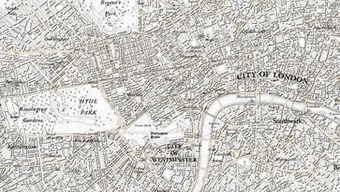
OS 225th anniversary map of London
21 June 2016 – Today Ordnance Survey (OS) is mining data used daily at all levels of national and local government, by the emergency services and large and small businesses. That data is also set to provide the foundation on which Great Britain will build its Smart future. Yet to celebrate its 225th anniversary, OS has returned to its roots and produced a map of modern London in the original OS style.
The London map has been created by cartographer, Chris Wesson, whose map of Mars earlier this year drew global praise for its simplicity and beauty. In an attempt to combine the best of old and new, Chris has kept the fonts and terminology as similar to the original 1801 map as was possible. He has also replicated the original marginalia, title and scale bar. The map also includes many up-to-date features – for example, the Emirates Air Line cable car that crosses the Thames.
For the map Chris has used the production size of OS Custom Made maps. This is so he can show as much of London as possible. To achieve this, the map was centred on the Houses of Parliament. Though in the map it is not labelled as Houses of Parliament, as Chris has kept the historic naming that showed the Palace of Westminster. He has also emulated the historic method of abbreviating names.
The place names on the map have all been manually added. It was a laborious, but enjoyable process for Chris that involved him printing out the map and comparing current and historic data to decide where to hand place the names.
Many of the features on the London map, such as railway lines, did not exist in 1801 when OS made its original map of Kent. So Chris has taken the earliest OS cartographic representations for each feature not represented in the original map. Therefore, the final product is a hybrid of maps from OS’s beginnings, as opposed to a direct copy of the 1801 Kent map.
Chris says: “The challenge was to create a mid-scale map, but the level of detail makes it more similar to a local level map. Essentially, the original 1801 map was a one inch to one mile or 1:63,360 map with a 1:10,000 data detail, as there were far less features and less urban sprawl at that time, so the product spec could at that time show more – such as field boundaries and all of the churches. We now have so many more features per unit area – which is why it’s shown at two inches to the mile and not one inch to the mile.
Chris continues: “Most of my time on making this map has been spent processing today’s high quantity of detailed data (with a different capture specification) to get it looking like the old map. For example, buildings alone were at least a 16-step process. Around 80% of my time has been spent preparing data and only 20% on cartographic styling, but when compared to the cartographers of the past their efforts would have been similarly weighted with a large emphasis on hand-drawing, especially once a common style had been agreed.”
Fellow cartographer, Charley Glynn, who was responsible for taking the look of digital mapping to the next level with his design for OS’s recent app release OS Maps, has also produced a map in an old style using modern data. Charley has chosen the West Highlands and produced a map in the 1967 style. One major difference in the original map and the modern version is the number of trig pillars. Although the map is dated and printed 1967, it was made using data captured in 1956 and the majority of trig pillars in the area were not built till the 1960s. There are 10–20 times more in the modern data. There are also many more roads and ferry routes in the modern data, although railways have stayed largely the same.
Charley says: “Mapping is an important part of OS heritage, and the lessons learned continue to feed into our future. The map I based my map on was published in 1967, but it was using data captured in 1956, which highlights how much things have changed today with our data refresh rates.”
The London map will be available for purchase in the near future. Register for an alert atos.uk/225map